Mapping Australia's Eastern Seabed: CSIRO Research Vessel Launches Key Coastal Survey Mission
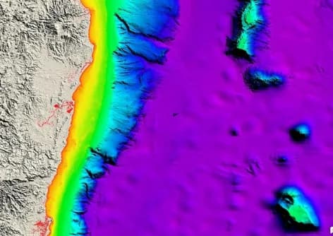
CSIRO's research vessel RV Investigator has set sail with a scientific team to update seafloor maps along a critical stretch of Australia's eastern coastline. The mission aims to provide more accurate bathymetric and topographic data to support marine science, ecosystem conservation, resource exploration, and navigational safety.
Highlights
- CSIRO's RV Investigator has launched a seafloor mapping mission targeting a critical stretch of Australia's eastern coastal waters.
- The vessel uses multibeam sonar to produce high-precision bathymetric and topographic surveys in both nearshore and deep-ocean environments.
- Survey data will be provided to marine management authorities, fisheries agencies, and maritime bodies to support conservation policy and navigational safety.
- Periodic seafloor map updates are necessary because existing charts often fail to reflect current underwater terrain or leverage modern survey accuracy.
- The mission contributes to global efforts to systematically map the ocean floor, large portions of which remain unsurveyed.
The RV Investigator, a research vessel operated by Australia's Commonwealth Scientific and Industrial Research Organisation (CSIRO), has departed with a scientific team on board to update seafloor maps covering a critical section of the country's eastern coastal waters.
Mission Background
Seafloor mapping is essential to marine scientific research, ecosystem conservation, resource exploration, and navigational safety. As survey technologies continue to advance, older seafloor charts frequently fail to capture the latest changes in underwater terrain, making periodic updates a priority for marine research institutions worldwide.
CSIRO and the RV Investigator
The RV Investigator is one of Australia's most advanced marine research vessels. Operated by CSIRO, the ship is equipped with high-precision survey instruments including multibeam sonar, enabling it to conduct detailed topographic surveys in both deep-ocean and nearshore environments across a wide range of sea conditions.
Significance of the Mission
This latest survey of Australia's eastern seaboard will deliver more accurate water-depth and terrain data to local marine management authorities, fisheries agencies, and maritime bodies. The results are expected to support the development of stronger ocean conservation policies and improve vessel navigational safety in the region.
Globally, vast stretches of the ocean floor remain unsurveyed in any systematic way. Missions such as this one play an important role in advancing the goal of producing a comprehensive map of the world's seabed.
原文來源: 查看原文
FAQ
Reviewed and published by the LAETimes editorial desk ·


