LiDAR Scanning Technology Powers Digital Models Behind Vivid Sydney's Spectacular Light Shows
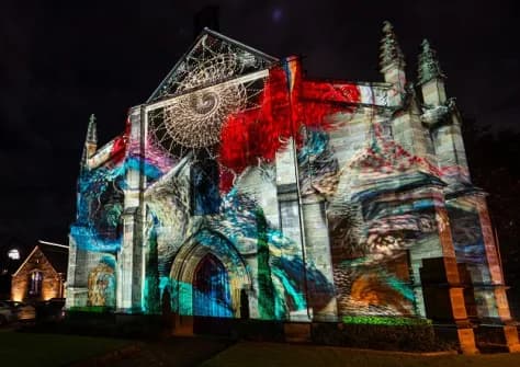
Sydney's annual Vivid Sydney festival relies on LiDAR architectural scanning to build precise digital twin models of buildings, enabling projection mapping artists to perfectly align complex light displays with every contour and detail of real-world structures. The technology has underpinned the event across multiple editions, with drone-based aerial surveying further improving accuracy and efficiency each year.
Highlights
- Vivid Sydney uses LiDAR architectural scanning to generate precise 3D point cloud data and digital twin models of landmark buildings as the foundation of its projection mapping workflow.
- LiDAR-derived digital twin models allow designers to simulate and fine-tune projection mapping in a virtual environment before any live display, ensuring perfect alignment with real building surfaces.
- LiDAR scanning has been central to Vivid Sydney's production process across multiple past editions, not only the current festival.
- Drone-based aerial surveying is increasingly integrated with LiDAR scanning at Vivid Sydney, improving model accuracy and production efficiency year over year.
- The combination of spatial data technology and large-scale live event production at Vivid Sydney sets a new global benchmark for creative applications of LiDAR and drone surveying.
Sydney's world-renowned annual light festival, Vivid Sydney, is celebrated for its breathtaking large-scale projection mapping displays on iconic architectural landmarks. Behind those immersive light shows lies a critical enabling technology: LiDAR (Light Detection and Ranging) architectural scanning.
How LiDAR Supports Projection Mapping
LiDAR technology works by emitting laser pulses and measuring the reflected signals to rapidly capture the precise three-dimensional geometry of buildings. The result is detailed point cloud data and high-accuracy digital models that serve as the backbone of the production pipeline.
For projection mapping — where complex visual content must be precisely aligned to the surfaces of large, irregular architectural facades — this level of accuracy is essential. Using LiDAR-derived digital twin models, designers and visual artists can simulate and fine-tune image mapping entirely within a computer environment before any projector is switched on. This pre-visualization process ensures that the final light display conforms perfectly to every corner, curve, and architectural detail of the real building.
A Technology That Has Underpinned Vivid for Years
According to reports, LiDAR architectural scanning has not only been central to the current edition of Vivid Sydney but has been a core part of the festival's production workflow across multiple past editions as well.
As scanning hardware continues to improve in precision, and as drone-based aerial surveying becomes more widely adopted, the efficiency and accuracy of digital model creation have improved year on year. This ongoing advancement allows creative teams to realize increasingly complex and immersive projection mapping experiences that push the boundaries of large-scale light art.
The convergence of spatial data technology and creative artistry demonstrates the breadth of real-world LiDAR applications — and sets a new technical benchmark for large-scale live event production worldwide.
原文來源: 查看原文
FAQ
Reviewed and published by the LAETimes editorial desk ·