GeoCue Announces TrueView LiDAR Sensor Payload Compatibility with Real-time Robotics Aerial Drone Platform
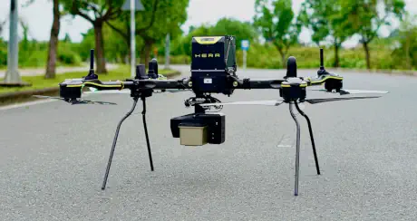
GeoCue, headquartered in Huntsville, Alabama, has announced that its TrueView LiDAR sensor payloads are now compatible with Real-time Robotics' aerial drone platform. The integration expands the TrueView product line's reach across commercial surveying, geospatial data collection, and infrastructure inspection applications, offering professionals greater hardware flexibility when selecting drone platforms.
Highlights
- GeoCue has confirmed that its TrueView LiDAR sensor payloads are now compatible with Real-time Robotics' aerial drone platform, expanding deployment options for professional users.
- The TrueView series, GeoCue's flagship LiDAR product line, is designed for high-accuracy point cloud data acquisition in surveying, environmental monitoring, and infrastructure inspection.
- Cross-brand payload-platform compatibility is an increasingly critical factor for professional drone users, and this announcement directly addresses that demand.
- GeoCue is headquartered in Huntsville, Alabama, and Real-time Robotics serves sectors including surveying, construction, energy, and public safety.
- The integration is expected to provide greater hardware flexibility to survey engineers, GIS professionals, and infrastructure asset managers executing aerial data acquisition missions.
HUNTSVILLE, Alabama — GeoCue has officially announced that its TrueView LiDAR sensor payloads are now compatible with Real-time Robotics' aerial drone platform. The move expands the TrueView product line's coverage across commercial surveying, geospatial data collection, and infrastructure inspection applications.
About the Integration
GeoCue's TrueView LiDAR sensor payload series has long been recognized for its high-accuracy point cloud data acquisition capabilities, seeing widespread adoption in professional applications including survey mapping, environmental monitoring, and infrastructure inspection. The confirmed compatibility with the Real-time Robotics drone platform means users can now integrate TrueView's high-performance payloads onto a broader range of aircraft, providing greater operational flexibility across diverse mission profiles.
Industry Significance
As LiDAR technology continues to gain traction in the drone sector, cross-brand compatibility between sensor payloads and multiple drone platforms has become an increasingly important consideration for professional users when selecting equipment. GeoCue's newly announced compatibility support is expected to deliver greater hardware choice to survey engineers, GIS professionals, and infrastructure asset managers.
"Compatibility between TrueView payloads and the Real-time Robotics platform gives our customers more options when executing aerial data acquisition missions." — GeoCue official statement
About GeoCue
GeoCue is headquartered in Huntsville, Alabama, and specializes in developing high-accuracy LiDAR sensor payloads and geospatial data processing solutions. The TrueView series serves as its flagship product line and is widely adopted across the global surveying and geospatial industries.
About Real-time Robotics
Real-time Robotics develops high-performance aerial drone platforms that support the integration of a variety of professional sensor payloads. The company serves sectors including surveying, construction, energy, and public safety.
Source: GeoCue official press release
原文來源: 查看原文
FAQ
Reviewed and published by the LAETimes editorial desk ·


