Aerial LiDAR Survey Pays Off: Clara Resources Identifies Seven Potential Gold Exploration Targets
Australian gold mining company Clara Resources has completed an aerial LiDAR scanning operation covering 39 square kilometres, successfully identifying seven potential mineral exploration targets. The geospatial data gathered will support the company's upcoming drilling and ground survey programmes, marking a significant step forward in technology-driven mineral exploration.
Highlights
- Clara Resources completed an aerial LiDAR survey covering 39 square kilometres at its gold exploration project in Australia.
- The survey identified seven potential mineral exploration target zones through micro-topographic feature analysis.
- LiDAR technology enables high-accuracy 3D terrain mapping even in densely vegetated or complex terrain, reducing exploration time and labour costs.
- Clara Resources will use the LiDAR survey results to plan the next phase of ground surveys and drilling operations.
- The case illustrates the growing role of geospatial technology in modernising traditional resource exploration workflows.
Aerial LiDAR Survey Delivers Major Breakthrough for Gold Exploration
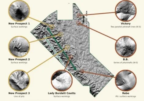
Australian gold mining company Clara Resources has completed a large-scale aerial LiDAR (Light Detection and Ranging) scanning operation covering 39 square kilometres, successfully identifying seven prospective mineral exploration targets from the survey data. The results lay an important foundation for the company's future mine development plans.
LiDAR Technology Applied to Mineral Exploration
LiDAR technology uses laser scanners mounted on drones or manned aircraft to precisely map surface topography and sub-canopy terrain features. Even in areas with dense vegetation or complex terrain, the technology can capture high-accuracy three-dimensional topographic data. This capability is making LiDAR increasingly valuable in the mineral exploration sector, significantly reducing the time and labour costs associated with traditional ground-based surveys.
Seven Potential Targets Identified
Through detailed analysis of subtle surface micro-topographic features captured during the aerial LiDAR campaign, Clara Resources has delineated seven target zones warranting further investigation. The identification of these targets will enable the company to allocate resources more effectively during subsequent drilling and geological survey operations, improving overall exploration efficiency.
Geospatial Technology Driving Mining Industry Modernisation
This case highlights the increasingly critical role that geospatial technology is playing in the traditional resources sector. Aerial surveying combined with LiDAR sensors not only accelerates the exploration process, but also delivers more objective and comprehensive geological information than conventional methods — helping mining companies make more precise investment decisions.
Clara Resources plans to use the findings from this survey to design the next phase of ground investigations and drilling works.
原文來源: 查看原文
FAQ
Reviewed and published by the LAETimes editorial desk ·


