TraX 'Fly Now' Button: Boosting Drone Pilot Visibility in Shared Airspace
German drone app TraX has introduced a 'Fly Now' (Jetzt fliegen) feature that allows pilots to broadcast their active flight zone in real time on a digital airspace map. Requiring no additional hardware, the feature is accessible to recreational and professional operators alike, supporting airspace transparency and situational awareness in line with modern UTM principles.
Highlights
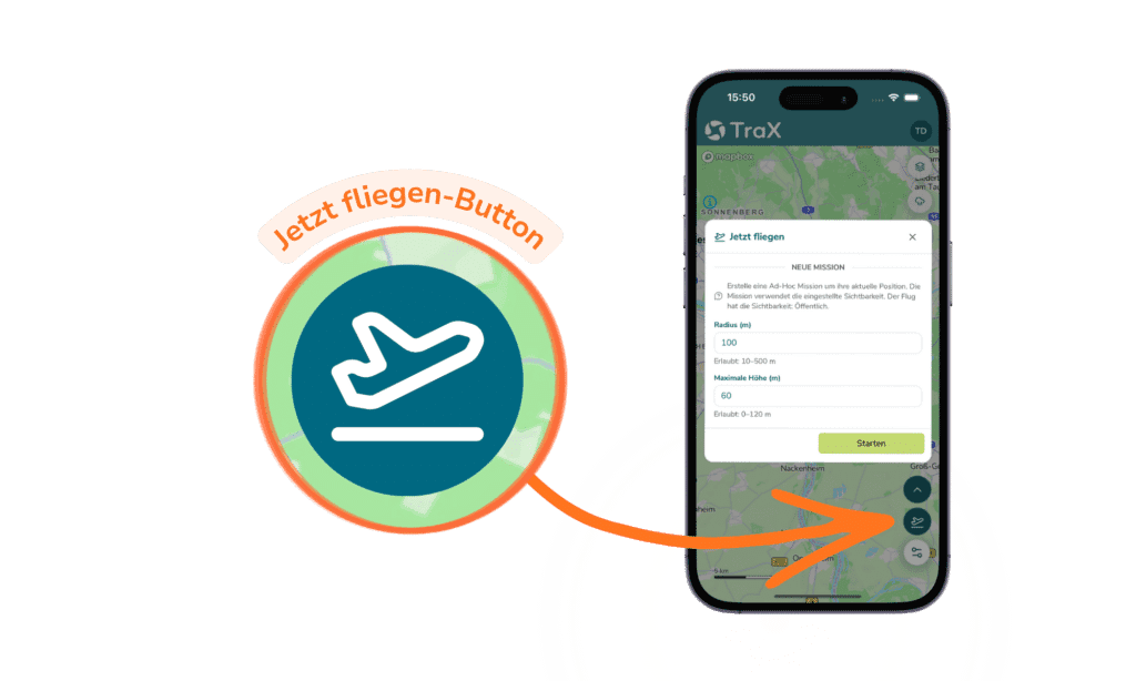
- TraX, a German drone app developed by Droniq, has launched a 'Fly Now' button that broadcasts a pilot's active flight zone onto a live digital airspace map with no additional hardware required.
- The feature generates a Common Operating Picture (COP) by allowing all TraX users to see where drone operations are currently taking place, directly supporting UTM airspace management principles.
- Unlike apps relying solely on ADS-B, TraX integrates multiple data sources and adds drone-specific information layers alongside active pilot visibility and flight feasibility validation.
- The 'Fly Now' function is designed for use cases including urban flights, infrastructure inspection, mixed-airspace missions, film production, and emergency response operations.
- The feature is accessible to both recreational and professional drone pilots, lowering the barrier to active airspace transparency without requiring regulatory certification or specialist equipment.
'Fly Now': Why Active Airspace Visibility Matters
Demand for drone operations continues to grow — whether for private recreational use or professional commercial applications. With that growth comes an increasing need for airspace safety, coordination, and transparency.
TraX, a modern drone app developed in Germany, was built precisely with these challenges in mind. Beyond flight planning and validation, active airspace visibility has become an increasingly critical capability for drone pilots.
At the heart of this is the 'Fly Now' button.
What Is the 'Fly Now' Button?
The 'Fly Now' button is a feature within the TraX app that enables drone pilots to publicly broadcast their current flight status in real time.
In practice, this means:
- The pilot's active flight area is displayed on a digital airspace map
- Other users can see that a drone operation is taking place in that area
- The overall Common Operating Picture (COP) for the airspace is improved
The core principle is straightforward: see others, and be seen by others.
Why Airspace Visibility Is So Important
1. Drones Must Yield to Manned Aircraft The fundamental rule is that unmanned aerial vehicles (UAVs) must actively give way to manned aircraft. Manned aircraft carry greater safety risk and hold right-of-way in air traffic to prevent collisions. This means drone pilots need as much situational awareness as possible — and must also make their own presence known.
2. Airspace Is Growing More Complex More drones and aircraft are sharing the same airspace than ever before. The assumption that "if I can't see anything, nothing is there" is no longer adequate.
3. Situational Awareness Is Now the Standard Professional drone operations today require a comprehensive airspace picture that ideally captures both manned and unmanned flight activity simultaneously.
How 'Fly Now' Works in Practice
The workflow is intentionally simple:
- Enable location services
- Activate 'Fly Now'
- Your active flight area appears on the airspace map in real time
The key advantage: no additional hardware required, no complex configuration.
This makes low-barrier airspace visibility available to all drone pilots for the first time — from hobbyists to professional operators.
Practical Benefits for Drone Pilots
Enhanced Flight Safety Other airspace users are informed that a drone operation is underway, reducing the potential for conflicts in the air.
Better-Informed Decision-Making Combined with real-time airspace situational awareness, TraX displays current airspace activity, enabling pilots to make more informed judgments both before takeoff and during flight.
Transparency for All Stakeholders A clearly visible flight area fosters mutual understanding among:
- Drone pilots
- Other airspace users
- Regulatory authorities and relevant agencies
Support for Professional Operations In commercial use cases such as infrastructure inspection, surveying and mapping, and emergency response missions, a clear airspace picture is mission-critical.
'Fly Now' and the Connection to Modern UTM Systems
Features like 'Fly Now' help make drone operations visible within the airspace and support the foundational principles of modern UTM (Unmanned Traffic Management) systems. These systems are designed to establish a Common Operating Picture and more effectively coordinate between different airspace users.
By enabling active drone visibility, airspace transparency is increased — laying the groundwork for safer coexistence in increasingly congested skies.
How TraX Differs from Conventional Flight Tracking Apps
Many flight tracking applications rely primarily on a single data source such as ADS-B.
TraX goes further by integrating multiple data sources to generate the most complete airspace situational picture possible, supplemented by:
- Active visibility (Fly Now)
- Drone-specific information layers
- Flight feasibility validation
The result: more relevant and actionable information for drone pilots.
Typical Use Cases for the 'Fly Now' Button
The 'Fly Now' feature is particularly well-suited for:
- Urban drone operations
- Inspection and construction site work
- Mixed-airspace missions
- Film and media production
- Emergency response and government agency operations
Conclusion: Visibility Is the Next Step in Drone Flight
As the drone market continues to evolve, so do the requirements for safety and transparency.
The 'Fly Now' button is more than just a feature — it represents an important step toward a coordinated, safer airspace that benefits all stakeholders.
TraX brings together three core elements:
- Flight validation
- Airspace situational awareness
- Active visibility
The app helps drone pilots fly more safely, more informedly, and more responsibly.
原文來源: 查看原文
FAQ
Reviewed and published by the LAETimes editorial desk ·


