Airborne LiDAR Uncovers Over 230,000 Hidden Gold Rush Sites and Hazardous Terrain Across Victoria, Australia
The Geological Survey of Victoria has completed a four-year airborne LiDAR mapping program, revealing more than 230,000 previously unrecorded mining relics buried beneath dense vegetation. The discoveries include abandoned mine shafts, tunnels, and prospecting pits dating to the 19th-century gold rush era, significantly advancing hazard identification, historical research, and land management across the state.
Highlights
- The Geological Survey of Victoria completed a four-year airborne LiDAR mapping program that identified over 230,000 previously unrecorded 19th-century gold rush mining features across the state.
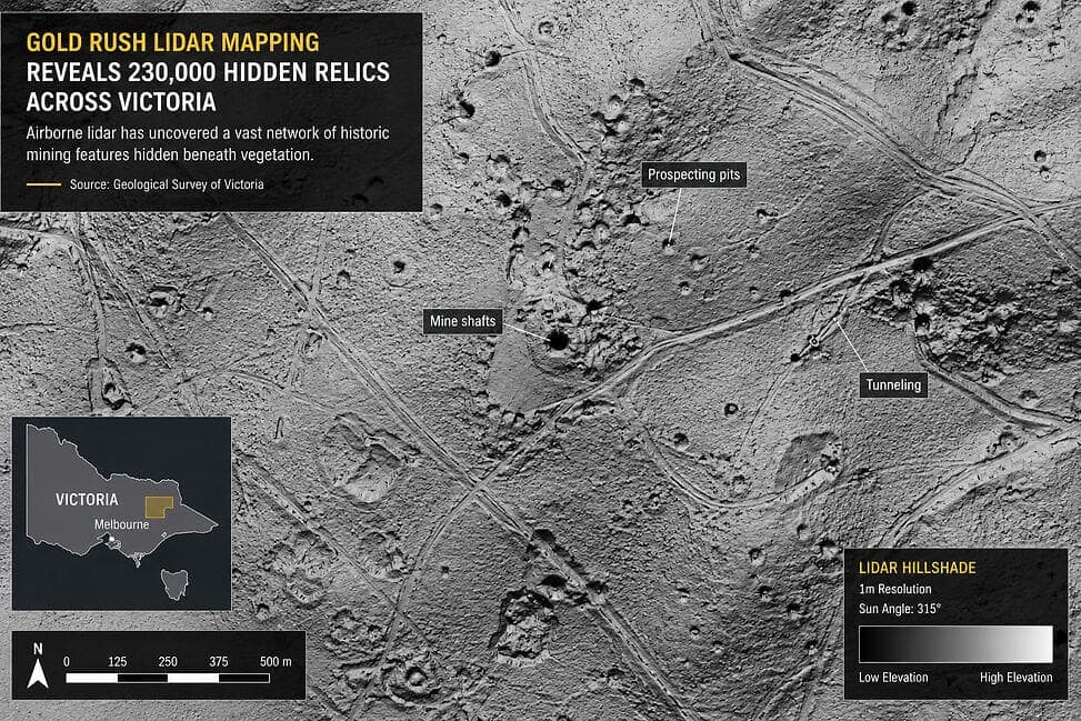
- Discovered features include abandoned mine shafts of unknown depth, underground tunnels showing surface subsidence, and shallow prospecting pits — all hidden beneath dense vegetation.
- Airborne LiDAR's ability to penetrate forest canopies and capture ground-level terrain data makes it significantly more effective than conventional aerial photography or ground surveys in vegetated terrain.
- Survey results will be used for public safety hazard marking, historical and archaeological research, and safer land-use planning by local government and land management agencies.
- The project establishes a replicable model for surveying other historic mining regions, highlighting the growing role of airborne remote sensing in cultural heritage protection and geological hazard management.
A large-scale, four-year aerial mapping program conducted by the Geological Survey of Victoria (GSV) is fundamentally reshaping our understanding of the region's gold rush heritage — and the hidden dangers it left behind — through the use of advanced airborne LiDAR technology.
Program Background
Victoria experienced a major gold rush in the mid-19th century, leaving behind countless mining remnants across the landscape. Many of these sites have long since been obscured by dense vegetation, making them impossible to detect through conventional ground surveys or traditional optical aerial photography. To address this challenge, the GSV deployed airborne LiDAR systems capable of firing laser pulses through forest canopies to capture precise, high-resolution terrain data at the ground surface.
Breakthrough Discoveries
The results of the four-year aerial survey have been extraordinary. The program identified more than 230,000 previously unrecorded mining features, including:
- Abandoned Mine Shafts: Structures of unknown depth and location that pose significant safety risks to anyone in the vicinity
- Underground Tunnels: Mining passages excavated by 19th-century miners, some of which show evidence of surface subsidence
- Prospecting Pits: Shallow excavations left by early gold seekers, scattered widely across the survey area
Wide-Ranging Applications
The survey data has proven valuable across multiple domains:
Hazard Identification and Public Safety
Abandoned mine shafts concealed beneath vegetation for decades present serious risks to bushwalkers, farmers, and developers. Detailed maps derived from LiDAR data enable authorities to mark hazards and implement appropriate risk management measures.
Historical Research
Mining areas that were poorly documented in historical records can now be spatially reconstructed using precise geospatial data, providing historians and archaeological researchers with a wealth of primary source material.
Land Management
Local governments and land management agencies can leverage the dataset to plan safer land use, while simultaneously protecting mining sites of historical significance.
The Key Advantage of LiDAR Technology
The fundamental difference between airborne LiDAR and conventional aerial photography lies in LiDAR's ability to generate point clouds that penetrate vegetation canopies and capture the true ground surface beneath. This capability makes it particularly well suited to the densely vegetated hill country of southeastern Australia, where it can reveal subtle terrain features that are completely invisible to the naked eye or standard imaging systems.
The success of this program sets an important precedent for survey work in other historic mining regions, demonstrating the enormous potential of drone-based and airborne remote sensing technologies in the fields of cultural heritage preservation and geological hazard management.
原文來源: 查看原文
FAQ
Newsletter
Subscribe to our Low-Altitude Industry Newsletter
Daily curated news on low-altitude economy and drone industry, delivered to your inbox.
Reviewed and published by the LAETimes editorial desk ·


