Super Typhoon Bavi Batters Northern Mariana Islands and Guam, Tracks Toward Asia
In early July 2026, Super Typhoon Bavi struck the U.S. Northern Mariana Islands and Guam with peak winds of 290 km/h (180 mph), causing widespread power outages, flooded roads, and structural damage. The third Category 5 storm of 2026, Bavi was still packing 250 km/h winds on July 8 as it crossed the Philippine Sea, with forecasts pointing toward Taiwan, the Ryukyu Islands, and mainland China. Meteorologists link its rapid intensification to a strong El Niño pattern.
Highlights
- Super Typhoon Bavi struck Guam and the Northern Mariana Islands on July 5, 2026, with peak sustained winds of 290 km/h (180 mph), causing power outages, flooded roads, and structural damage.
- Bavi is the third tropical cyclone of 2026 to reach Category 5 intensity on the Saffir-Simpson Hurricane Wind Scale.
- On July 8, Bavi maintained sustained winds of 250 km/h (155 mph) while crossing the Philippine Sea westward, with forecasts tracking toward Taiwan, the Ryukyu Islands, and mainland China.
- Sea surface temperatures in the storm's path measured approximately 30°C (86°F), contributing to rapid intensification.
- Meteorologist Jeff Masters (Yale Climate Connections) attributes the storm's strength to a strong El Niño pattern, which causes typhoons to form farther east and travel longer over warm water before striking Asia.
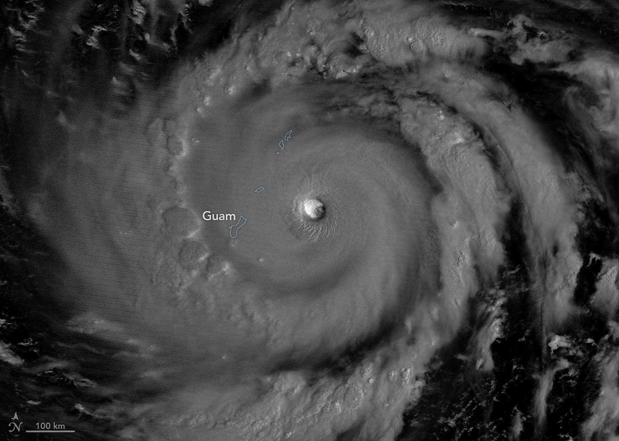
In early July 2026, powerful Super Typhoon Bavi swept across the U.S. Northern Mariana Islands and Guam — the second major typhoon to strike this stretch of the North Pacific within three months. Bavi reached peak intensity on the night of July 5 as it bore down on the island chain, bringing sustained winds of 290 km/h (180 mph) along with torrential rain and dangerous storm surge.
NASA Satellite Imagery Captures Typhoon Eye Wall
The VIIRS (Visible Infrared Imaging Radiometer Suite) instrument aboard the NOAA-20 weather satellite captured a nighttime image at approximately 15:30 UTC on July 5 (1:30 a.m. local time on July 6), clearly showing Bavi's eye. A waning gibbous moon illuminated the western side of the eye wall. Within hours of the image being taken, the eye passed over Rota Island, located just north of Guam.
Rapid Intensification: The Third Category 5 Storm of 2026
Bavi was upgraded to super typhoon status in the early hours of July 4 (local time) as it tracked westward over warm ocean waters. Satellite observations recorded sea surface temperatures in the area at approximately 30°C (86°F). Bavi became the third tropical cyclone of 2026 to reach Category 5 intensity on the Saffir-Simpson Hurricane Wind Scale.
Widespread Damage — Months After Super Typhoon Sinlaku
News reports documented severe damage across Guam, Rota, and Saipan, including downed utility poles and cables, roads flooded and blocked by debris, and structural damage to buildings — including a water distribution station on Rota. U.S. Coast Guard personnel subsequently worked to clear navigational hazards and helped reopen ports around Guam and the Northern Mariana Islands once sea conditions improved. The destruction came just months after Super Typhoon Sinlaku brought powerful winds and heavy rainfall to the same region in mid-April.
July 8 Update: System Tracks Toward Taiwan and the Ryukyus
As of July 8, Bavi remained at typhoon strength while crossing the Philippine Sea heading westward. The latest imagery captured by the VIIRS instrument on NOAA-21 at approximately 04:30 UTC that day showed the National Weather Service reporting maximum sustained winds of 250 km/h (155 mph). Forecasts indicate the storm's track may curve to the northwest toward Taiwan, Japan's southern Ryukyu Islands, and mainland China, with gradual weakening expected over the coming days.
Meteorologists: El Niño Conditions May Be Fueling the Storm's Intensity
Meteorologist Jeff Masters, writing in Yale Climate Connections, noted that Bavi is precisely the type of typhoon that can emerge when a strong El Niño is developing. He explained that during El Niño years, typhoons tend to form farther east, giving them a longer journey over warm ocean waters to intensify before turning toward Asia — "greatly increasing the odds that they reach Category 5 intensity."
NASA Earth Observatory imagery produced by Michala Garrison, using data from NASA EOSDIS LANCE, GIBS/Worldview, and the Joint Polar Satellite System (JPSS). Typhoon track data provided by the U.S. Naval Research Laboratory. Written by Lindsey Doermann.
原文來源: 查看原文
FAQ
Reviewed and published by the LAETimes editorial desk ·


