Satellite Imagery Uncovers the Mystery Behind Harmful Algal Blooms at Colorado's Blue Mesa Reservoir
USGS and National Park Service researchers analyzing decades of satellite and field data from Blue Mesa Reservoir in Colorado have found that harmful algal blooms are significantly more likely when water levels fall below 7,470 feet and water temperatures exceed 19.5°C. The severe 2021 drought dropped the reservoir to its lowest level since 1984, triggering toxic cyanobacteria blooms that released microcystin, posing serious public health risks. Similar conditions are returning in 2026.
Highlights
- USGS 研究員 Tyler King 確認:Blue Mesa 水庫水位低於 7,470 英尺且水溫超過 19.5°C 時,有害藻華爆發頻率顯著上升。
- 2021 年嚴重乾旱導致 Blue Mesa 水庫降至 1984 年以來最低水位,藍綠藻大量繁殖並釋放具毒性的微囊藻毒素。
- 藻華通常從水庫東側最淺的 Iola 盆地開始,衛星影像顯示有時向西蔓延至約三分之二水庫長度,但毒素超標通常局限於 Iola 盆地。
- 截至 2026 年 6 月 27 日,Blue Mesa 水庫蓄水量僅達正常水平的 43%,為過去 30 年同日最低紀錄,相同危機條件正在重演。
- USGS WaterMAP、NASA STREAM 與多機構 CyAN 計畫整合 Landsat 及 Sentinel-2 資料,可在衛星過頂後數小時內提供藻華早期預警,輔助現地採樣決策。
Drought Hammers Blue Mesa, Setting the Stage for an Algal Crisis
The summers of 2021 and 2022 were brutal for Blue Mesa Reservoir in Colorado. A severe drought gripping much of the American West, combined with emergency water releases, pushed the reservoir to its lowest level since 1984. Boat ramps and marinas were forced to close, the ruins of a long-submerged ghost town re-emerged from the mud, and portions of the water turned an eerie green — choked with toxic cyanobacteria blooms.
Scientists from the U.S. Geological Survey (USGS) and the National Park Service (NPS) have now analyzed decades of data from Blue Mesa Reservoir to establish the link between low water levels, elevated water temperatures, and harmful algal bloom (HAB) events.
"When water levels drop below 7,470 feet and water temperatures exceed approximately 19.5°C (67.1°F), bloom frequency increases markedly," said USGS research hydrologist Tyler King. Such low-water conditions are not unusual — they have recurred at the reservoir every few years in recent decades.
The Toxic Threat of Cyanobacteria
While trace amounts of cyanobacteria are always present in the reservoir, the problem emerges when certain species proliferate en masse. Species such as Aphanizomenon, Dolichospermum, and Woronichinia thrive particularly well in warm, stagnant water. When they do, they release microcystin — a toxin capable of causing skin and eye irritation, respiratory problems, and liver damage. Children and pets are especially vulnerable due to their smaller body mass and proportionally higher water intake.
Satellite Data: A 'Time Machine' for Scientists
King and his team analyzed both field water samples and satellite observations from the European Space Agency's Sentinel-2 mission and NASA/USGS Landsat satellites. Sentinel-2's sensors can detect chlorophyll — the photosynthetic pigment — making it particularly effective for mapping bloom locations. Landsat sensors were used to track long-term water temperature changes.
The NPS and USGS formally launched the research program in 2021 after receiving anecdotal reports and water sample results indicating unusually high cyanobacteria concentrations. Scientists not only collected new samples but also worked backward through historical records and satellite imagery — a process King described as a "time machine" that allowed researchers to examine reservoir conditions before systematic water sampling began. The dataset includes satellite chlorophyll records dating back to 2016, water temperature data from 2000, and on-site water-level measurements stretching back to the 1970s.
Blooms Typically Originate in the Iola Basin
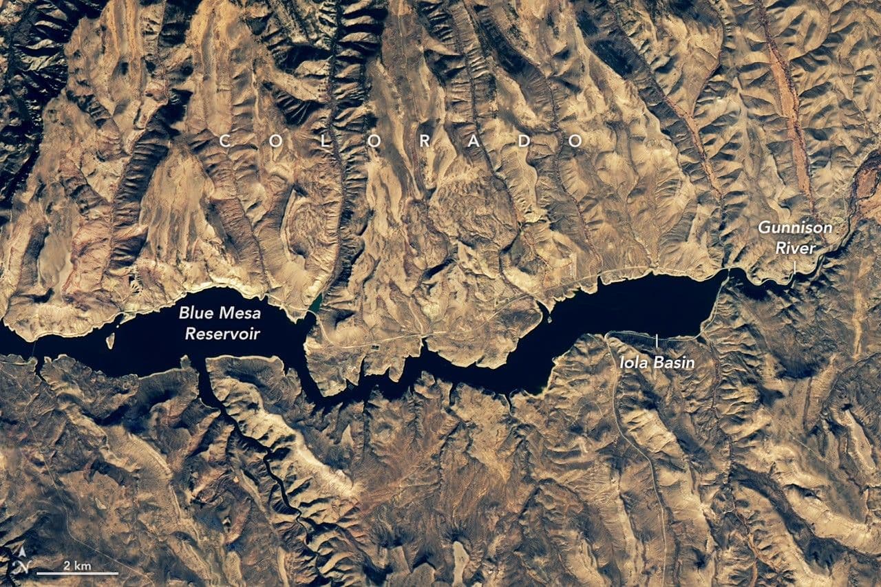
Satellite data revealed that blooms typically begin in the Iola Basin — the easternmost section of the reservoir, where the Gunnison River enters and the water is shallowest. Imagery occasionally captured blooms spreading westward into other parts of the reservoir, sometimes extending across roughly two-thirds of its length. However, toxin concentrations exceeding health advisory thresholds were generally confined to the Iola Basin.
2026: Warning Bells Ring Again
King noted that the same conditions responsible for the 2021–2022 crisis are re-emerging in 2026. Drought has again spread across much of the western United States, mountain snowpack is sparse, and Blue Mesa's water level remains critically low. As of June 27, 2026, the reservoir held approximately 43% of its normal storage for that date — the lowest on record for that day in the past 30 years. The U.S. Bureau of Reclamation projects water levels will continue to decline through October.
Should another bloom occur in 2026, researchers expect satellites to play a key monitoring role. The team currently uses USGS's WaterMAP (Water Monitoring Above the Planet) tool to track potential bloom conditions within hours of a satellite overpass. NASA's STREAM (Satellite-based Tool for Rapid Evaluation of Aquatic Environments) program also integrates Landsat and Sentinel-2 data to map potential bloom areas within hours of each overpass. Meanwhile, the multi-agency CyAN (Cyanobacteria Assessment Network) program collects daily satellite data to monitor bloom conditions across large bodies of water.
"It's remarkable to be able to track the effects of microorganisms — invisible to the naked eye — from nearly 500 miles (approximately 800 kilometers) above Earth," King said. He was quick to emphasize, however, that field sampling and direct toxin testing remain indispensable. "Satellites are not the final word," he added. "They can tell us where problems might be developing, but toxins often don't appear until late in a bloom's lifecycle."
Satellite observation data can help managers determine where to deploy personnel to collect water samples for detailed bloom toxicity analysis, making it a valuable complement to ground-level monitoring.
NASA Earth Observatory images by Michala Garrison, using USGS Landsat data. Photographs by Katie Walton-Day (USGS) and Nicole Gibney (NPS). Article by Adam Voiland.
原文來源: 查看原文
FAQ
Reviewed and published by the LAETimes editorial desk ·


