DFR 3.0: The Next Evolution of Drone as First Responder Programs
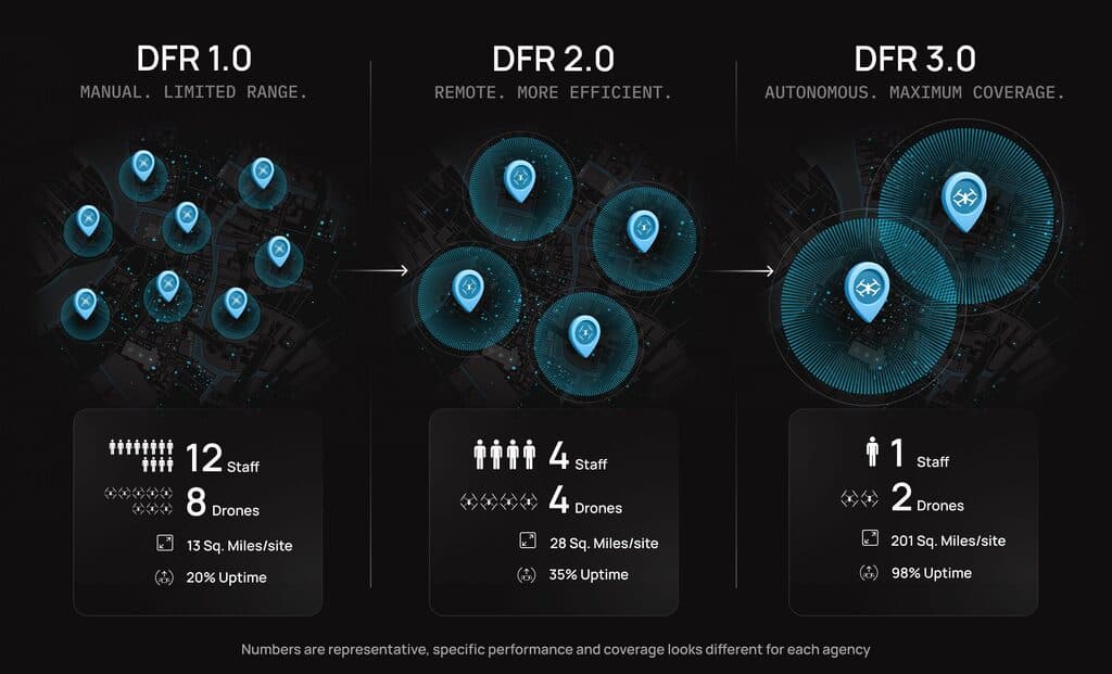
Drone as First Responder (DFR) programs have evolved over eight years from proof-of-concept (DFR 1.0) to docking-station deployments integrated with real-time crime centers (DFR 2.0). Now, DFR 3.0 emerges as an autonomous, adaptive, infrastructure-grade capability. BRINC's Guardian drone—featuring 90-second automated battery swaps, up to 8-mile range, multi-carrier connectivity switching, and automotive-grade radar—redefines around-the-clock autonomous aerial emergency response.
Highlights
- BRINC's Guardian drone performs an automated battery swap in 90 seconds, enabling approximately 98% operational availability compared to the ~35-minute contact-charging time required by platforms such as the Skydio X10.
- The Guardian extends DFR operational range to up to 8 miles, expanding single-station coverage from roughly 30 square miles to up to 200 square miles—nearly 7× the footprint of legacy systems.
- DFR 3.0 integrates intelligent multi-carrier connectivity switching and Starlink satellite backup, enabling reliable command and control in areas with poor or no cellular coverage.
- The Guardian supports automated payload swapping with a 10-lb capacity, allowing agencies to carry mission-specific equipment such as AEDs, naloxone, radiation detectors, or flotation devices without manual intervention.
- DFR 3.0 employs automotive-grade radar for obstacle detection, improving all-weather autonomous flight reliability while reducing onboard computing demands compared to vision-based AI architectures.
Drone as First Responder (DFR) programs have evolved rapidly over the past eight years. What began as pilot projects validating proof-of-concept (DFR 1.0) matured into strategically deployed docking-station systems integrated with real-time crime centers (DFR 2.0).
Now, a new phase is taking shape. DFR 3.0 represents autonomous, adaptive, infrastructure-grade emergency response capability. This shift is driven by the BRINC Guardian—a purpose-built drone that fundamentally redefines what is possible for all-weather, automated aerial emergency response.
DFR 3.0 is not an incremental upgrade. It represents a fundamental change in system availability, coverage cost-efficiency, and operational use cases.
The Key to Achieving True 24/7 Operations
The biggest operational limitation of DFR 2.0 was charging time. Traditional docking-station systems use contact charging: after completing a mission, the drone lands and must remain stationary while recharging—often for as long as the flight itself.
Take contact-charging platforms such as the Skydio X10 as an example: charging from 15% to 95% takes approximately 35 minutes. By contrast, the Guardian's automated battery swap takes just 90 seconds—provided the docking station has a fully charged spare battery ready.
This difference compounds quickly in high-frequency deployment environments. In a scenario with continuous call volume over a 24-hour period, a contact-charging drone spends more than half its operational time sitting on the ground recharging. An automated battery-swap system, on the other hand, can achieve close to 98% availability, because turnaround time between missions is measured in seconds rather than half-hours.
This fundamentally changes the cost-efficiency of deployment. Instead of installing multiple docking stations at a single location to maintain coverage while one unit charges, agencies can sustain around-the-clock readiness from a single station. Capital previously allocated to redundancy can instead be redirected toward expanding coverage. DFR 3.0 doesn't just mean flying more often—it means making continuous standby an infrastructure-grade capability.
Redefining Operational Range
Flight endurance directly affects range. Early BVLOS waivers restricted drone operations to a 2–3 mile radius, but many agencies have since obtained jurisdictional waivers allowing flight anywhere within their service area—provided the drone can safely reach the scene.
However, many legacy DFR systems remain constrained to that 2–3 mile operational envelope. The Guardian extends this boundary to up to 8 miles, enabled by improvements in both endurance and connectivity—a core breakthrough of DFR 3.0.
Greater range dramatically expands coverage area. A single station that previously covered roughly 30 square miles can now cover up to 200 square miles—nearly seven times the footprint of a traditional system. Agencies can therefore cover larger territories with fewer drone bases.
Agencies must also consider overlapping coverage for simultaneous incidents and rapid-response needs in high-crime areas. For systems capable of true 24/7 operations, deploying a smaller number of strategically overlapping long-range systems is far more cost-effective than clustering multiple short-range systems in the same area.
Connectivity Resilience Built for Real Coverage Gaps
DFR reliability depends on connectivity quality.
DFR 1.0 required human operators not only because of regulatory constraints, but also because it relied solely on point-to-point radio control.
DFR 2.0 introduced cellular-integrated drones with radio as a backup layer of reliability—but many areas still face inconsistent cellular coverage.
DFR 3.0 addresses this through intelligent multi-carrier switching, automatically transitioning to an alternate carrier when signal quality degrades.
In environments with no cellular coverage at all, integration with Starlink provides satellite-backed command and control, making DFR deployment in previously impractical remote locations a reality.
For example, wildfire-prone regions or parks that frequently require search-and-rescue operations can now establish permanent emergency response infrastructure. This delivers better outcomes and at a fraction of the cost compared to helicopters—historically the only viable option.
Once airborne, the Guardian maintains stable connectivity. Redundant communication paths reduce mission risk and increase confidence in autonomous deployment.
From Observation to Intervention
Early DFR generations were camera-centric—the drone arrived on scene, streamed video, and assisted decision-making. That capability remains essential, but DFR 3.0 expands the mission scope from observation to intervention.
The Guardian features automated payload swapping and a 10-pound (approximately 4.5 kg) payload capacity, enabling mission-specific equipment to be carried without manual intervention. The drone no longer just "sees the problem"—it can actively "respond to the problem."
- Facilities near nuclear sites or high-risk urban areas: radiation detectors can be deployed
- Assisted living communities: AEDs (automated external defibrillators) can be delivered
- Areas facing opioid overdose crises: Narcan (naloxone) can be carried and deployed
- Waterfront communities: life-saving devices such as Restube flotation aids can be deployed at scale
This flexibility also extends the equipment's lifecycle value. As new payloads become compatible, the drone's utility continues to grow. Agencies are no longer locked into a static camera platform—they gain a modular aerial emergency asset that evolves with their operational needs.
The Guardian also features an integrated loudspeaker rated at up to 131 dBa—three times louder than a police vehicle—ensuring effective command, communication, and crowd management in any environment.
Rethinking Autonomous Flight Capability
As self-driving vehicles begin offering commercial taxi services, the debate over imaging sensor architecture seems to be reaching a conclusion.
Early discussions focused on the trade-offs between visual cameras and LiDAR. For ground vehicles, cameras benefit from clearly marked lane lines, predictable signage, and ground-level reference points—yet even the best systems combine cameras with radar or LiDAR.
Widely circulated videos titled "Can You Fool a Self-Driving Car?" have demonstrated the vulnerability of camera-only systems to interference and confusion. In aerial environments, this vulnerability is even more pronounced.
Drones operate in unstructured three-dimensional space, confronting low-contrast surfaces such as water, buildings that generate multipath reflections, and thin obstacles such as power lines. Weather presents an additional challenge—rain, fog, and smoke all degrade optical sensor performance.
DFR 3.0 employs automotive-grade radar, drawing on sensor architectures similar to those used by safety-focused manufacturers such as Volvo, to enhance obstacle detection and environmental awareness. Radar is less affected by lighting conditions, performs more consistently in adverse weather, and can detect objects that visual systems might miss.
Radar also demands fewer onboard computing resources than vision-based AI architectures. That efficiency gain translates into longer flight times and greater operational reliability. For public safety agencies, autonomous capability must be dependable under the worst conditions—not just in ideal environments.
From Program to Permanent Infrastructure
DFR 1.0 proved that drones could be first on scene. DFR 2.0 scaled deployment through docking stations and automation. DFR 3.0 transforms DFR into permanent, resilient emergency response infrastructure.
Automated battery swapping delivers near-continuous availability. Adaptive payload systems broaden mission scope. Resilient connectivity ensures command and control in difficult coverage areas. Radar-enhanced autonomy supports all-weather operations. Under these conditions, the Guardian's role has fundamentally changed—it is no longer just a flying camera but a routine aerial emergency asset integrated into 911 dispatch workflows.
Agencies adopting DFR 3.0 are not simply upgrading hardware. They are rebuilding the way aerial emergency response is woven into daily operations—expanding coverage, reducing redundancy costs, and improving reliability in the environments that matter most.
To learn more about BRINC's DFR 3.0 solutions, contact BRINC directly.
原文來源: 查看原文
FAQ
Newsletter
Subscribe to our Low-Altitude Industry Newsletter
Daily curated news on low-altitude economy and drone industry, delivered to your inbox.
Reviewed and published by the LAETimes editorial desk ·


