New Zealand Coastal LiDAR Mapping Reaches Major Milestone: 118 Billion Point Cloud Dataset Released
New Zealand has completed Phase 2 of its 3D Coastal Mapping Program, releasing a dataset of 118 billion point cloud data points. The publicly available data supports coastal erosion monitoring, flood risk assessment, infrastructure planning, environmental research, and climate change response, marking a landmark achievement in the country's geospatial infrastructure.
Highlights
- New Zealand's 3D Coastal Mapping Program Phase 2 has been completed, releasing 118 billion LiDAR point cloud data points to the public.
- The dataset was collected using airborne LiDAR technology and covers New Zealand's entire national coastline at high precision.
- All point cloud data is freely accessible to government agencies, academic institutions, and private enterprises.
- Key applications include coastal erosion monitoring, flood risk assessment, infrastructure planning, and long-term sea-level rise baseline tracking.
- The program is regarded as a reference model for other countries pursuing large-scale national coastal LiDAR mapping initiatives.
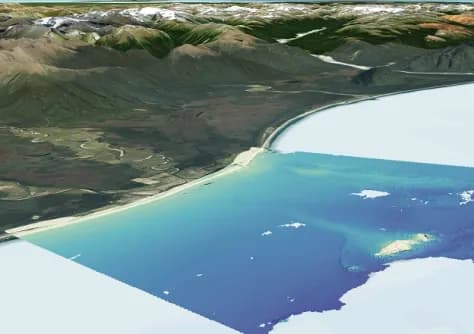
New Zealand has officially completed Phase 2 of its 3D Coastal Mapping Program, releasing a dataset comprising 118 billion point cloud data points — setting a new benchmark for coastal terrain research and environmental management in the country.
Program Background
The 3D Coastal Mapping Program uses airborne LiDAR (Light Detection and Ranging) technology to conduct high-precision three-dimensional scanning of New Zealand's entire coastline, capturing detailed topographic data. Phase 1 established the program's foundational framework, while the now-completed Phase 2 has significantly expanded both the coverage and volume of data collected. All point cloud data has been made publicly available for use by any interested party.
Scale and Significance of the Dataset
The release of 118 billion point cloud data points represents a major leap forward in New Zealand's geospatial information infrastructure. This high-density 3D dataset has wide-ranging applications, including:
- Coastal erosion monitoring: Precisely tracking changes in coastline position over time
- Flood risk assessment: Helping government agencies develop disaster preparedness and response strategies
- Infrastructure planning: Providing accurate topographic references for engineering and construction projects
- Environmental and ecological research: Supporting academic institutions in coastal ecosystem analysis
- Climate change response: Serving as baseline data for long-term sea-level rise monitoring
Open Data Access and Future Applications
The point cloud dataset has been formally released to the public, with government agencies, academic research institutions, and private enterprises all able to freely access and utilize the data. The release is expected to drive further development in New Zealand's geospatial data applications, drone-based surveying, and digital land management sectors.
This achievement not only demonstrates the powerful capability of airborne LiDAR surveying technology for large-scale geographic data collection, but also provides a valuable reference model for other countries looking to launch similar coastal mapping initiatives.
原文來源: 查看原文
FAQ
Newsletter
Subscribe to our Low-Altitude Industry Newsletter
Daily curated news on low-altitude economy and drone industry, delivered to your inbox.
Reviewed and published by the LAETimes editorial desk ·