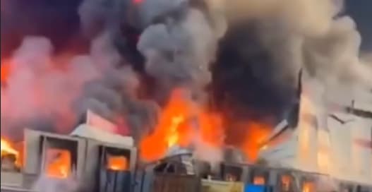
Drone LiDAR and Photogrammetry in Action: 3D Disaster Mapping After Saskatchewan's Wolf Fire
Following the 2025 Wolf Fire in Denare Beach, Saskatchewan, Canada, Stitch3D deployed a hybrid drone LiDAR and photogrammetry workflow to map approximately 200 acres of fire-affected terrain in near real time. The operation supported damage assessment, earthworks planning, and post-disaster recovery, demonstrating the frontline value of modern reality capture technology in emergency response.
Highlights
- The 2025 Wolf Fire near Denare Beach, Saskatchewan prompted Stitch3D to deploy a hybrid drone LiDAR and photogrammetry workflow covering approximately 200 acres (80.9 hectares) of fire-damaged terrain.
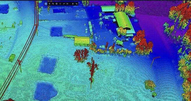
- LiDAR sensors penetrated residual smoke and vegetation to capture terrain and structural data in low-visibility conditions, while photogrammetry provided high-resolution orthomosaic imagery and textured 3D models.
- Data from both sensors were fused on the Stitch3D platform to generate a comprehensive, high-accuracy 3D model, compressing multi-day ground surveys into hours of aerial mapping.
- The 3D dataset directly supported three operational needs: insurance and government damage assessment, earthworks and road restoration planning, and ongoing post-fire recovery tracking.
- The Wolf Fire mission demonstrates that drone LiDAR mapping has matured beyond large engineering projects and can now be rapidly deployed as a frontline tool in emergency disaster response.
Drone LiDAR in Wildfire Disaster Response: A Field Report from Saskatchewan's Wolf Fire
In 2025, a wildfire known as the Wolf Fire broke out near Denare Beach in Saskatchewan, Canada. Emergency response teams immediately deployed a hybrid aerial mapping workflow combining drone-mounted LiDAR (Light Detection and Ranging) and photogrammetry, covering a total survey area of approximately 200 acres (about 80.9 hectares) across multiple affected zones.
Stitch3D: The Platform Accelerating Real-Time Disaster Response
The operational backbone of this mission was the Stitch3D platform, whose integrated workflow enabled field personnel to collect and process high-accuracy 3D spatial data concurrently with the ongoing disaster — rather than waiting for conditions to stabilize before conducting ground surveys. This real-time capability proved critical for time-sensitive response decisions.
A Hybrid Technical Workflow
The mission ran LiDAR scanning and photogrammetry in parallel:
- LiDAR Scanning: Capable of penetrating residual smoke and vegetation, LiDAR precisely captured terrain relief and structural outlines even in low-visibility conditions.
- Photogrammetry: Generated high-resolution orthomosaic imagery and textured 3D models, providing visual documentation of the extent of damage.
- Data Fusion: Outputs from both technologies were integrated within the Stitch3D platform to produce a comprehensive, high-accuracy 3D model of the disaster zone.
Three Core Application Objectives
The mapping mission served three primary purposes:
- Damage Assessment: Accurately documented fire impacts on structures, roads, vegetation, and land condition — providing objective data for insurance claims and government evaluation.
- Earthworks Planning: 3D terrain models enabled engineers to plan road restoration, cut-and-fill operations, and site preparation in advance.
- Recovery Support: Ongoing spatial data updates allowed teams to track recovery progress and inform subsequent reconstruction decisions.
Real-World Validation of Modern Reality Capture Technology
The Wolf Fire response was more than a technology demonstration — it was a comprehensive field validation of modern reality capture techniques under genuine disaster conditions. The high mobility of drones combined with the penetration capability of LiDAR sensors compressed what would traditionally have required days or even weeks of ground survey into aerial mapping completed within hours.
This case clearly illustrates that as drone hardware performance improves and cloud-based data processing platforms mature, LiDAR mapping is no longer the exclusive domain of large-scale engineering projects. It is a practical tool that can be rapidly deployed on the front lines of emergency disaster response.
Implications for Disaster-Prone Regions
For regions regularly threatened by typhoons, earthquakes, landslides, and other natural hazards, integrated drone LiDAR and photogrammetry rapid-mapping workflows offer significant potential to improve both the efficiency and accuracy of initial disaster assessment. The adoption of these technologies and platforms could meaningfully strengthen disaster response systems in vulnerable areas worldwide.
原文來源: 查看原文
FAQ
Reviewed and published by the LAETimes editorial desk ·