Project Moonraker: NUVIEW Selected by ESA to Advance Space-Based LiDAR Technology on the Moon
US LiDAR company NUVIEW has been selected by the European Space Agency (ESA) to participate in the 'Moonraker' lunar mission, deploying space-based LiDAR to map the Moon's surface in high-resolution 3D. The mission aims to improve landing safety, reduce mission risk, and validate the commercial case for space-based LiDAR applications back on Earth.
Highlights
- NUVIEW has been selected by the European Space Agency (ESA) to deploy a space-based LiDAR system as part of the lunar 'Moonraker' mission.
- The Moonraker mission will produce high-resolution 3D terrain maps of the Moon's surface to support rover navigation, landing site selection, and future lunar base planning.
- LiDAR's ability to operate in darkness and shadowed regions makes it particularly suited to mapping permanently shadowed craters near the lunar south pole.
- Successful lunar validation of NUVIEW's space-based LiDAR is expected to strengthen the commercial case for Earth-orbit remote sensing applications including carbon monitoring and urban modeling.
- ESA's selection of NUVIEW for Moonraker significantly raises the company's profile in the global space technology and remote sensing industries.
NUVIEW Chosen by ESA for Lunar LiDAR Mission
Lunar exploration is entering a new, operationally significant phase — one that encompasses repeated access, combined robotic and crewed missions, resource assessment, infrastructure planning, and sustained surface operations. At the heart of this ambition lies a critical requirement: reliable, high-fidelity terrain data.
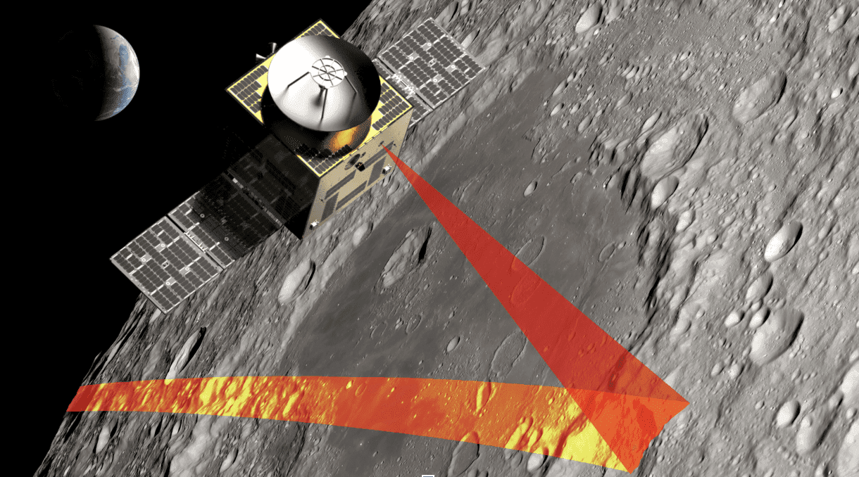
It is against this backdrop that US LiDAR technology company NUVIEW has been selected by the European Space Agency (ESA) to take part in a lunar mission designated "Moonraker." The mission will deploy a space-based LiDAR system to conduct high-precision 3D terrain mapping of the lunar surface, providing essential data to support rover path planning, landing site selection, and future lunar base construction.
Why the Moon?
The strategic importance of lunar exploration is growing rapidly. Multiple national space agencies and private organizations are pushing forward with plans for lunar resource extraction, scientific research, and future crewed missions. However, the Moon's surface — pocked with craters, steep slopes, and boulder fields — presents serious safety challenges for landers, rovers, and astronauts alike.
Conventional optical imaging can provide overhead views but struggles to accurately capture terrain relief and depth information. LiDAR (Light Detection and Ranging) technology works by emitting laser pulses and measuring the time it takes for them to return, generating high-resolution 3D point cloud maps. Critically, LiDAR operates effectively in darkness and shadowed areas — making it especially well-suited for exploring regions such as the permanently shadowed craters near the lunar south pole.
The Core Technical Value of the Moonraker Mission
NUVIEW's space-based LiDAR system offers several key advantages for lunar operations:
- Enhanced mission safety: Precise terrain data enables planners to chart safer descent trajectories and surface traversal routes.
- Reduced mission risk: Prior knowledge of terrain hazards and obstacles significantly lowers the probability of mission failure.
- Infrastructure planning support: Reliable surface data underpins site selection for lunar bases, road planning, and the deployment of resource extraction equipment.
- Strengthened commercial case: Successful validation in the lunar environment will reinforce the commercial viability of space-based LiDAR for Earth remote sensing applications.
Technology Spin-Off: From the Moon Back to Earth
NUVIEW's participation in the Moonraker mission is not only a scientific milestone — it carries significant commercial strategic value. Successfully validating space-based LiDAR in the lunar environment will pave the way for deploying the technology in Earth orbit, enabling applications such as high-precision topographic mapping, forest carbon stock monitoring, urban 3D modeling, and disaster risk assessment.
With ESA's endorsement through the Moonraker selection, NUVIEW's competitive standing in the global space technology and remote sensing industries has been substantially elevated. The mission also injects new momentum into the broader commercial ecosystem for space-based sensing technologies.
Outlook
A new era of lunar exploration has begun. From terrain mapping to resource assessment, from robotic precursor missions to permanent human settlement, accurate and reliable spatial sensing will underpin every step of the journey. With Project Moonraker, NUVIEW is positioning itself at the forefront of this space technology revolution.
原文來源: 查看原文
FAQ
Newsletter
Subscribe to our Low-Altitude Industry Newsletter
Daily curated news on low-altitude economy and drone industry, delivered to your inbox.
Reviewed and published by the LAETimes editorial desk ·