Students Blend NASA Science and Indigenous Knowledge to Study Coastal Erosion
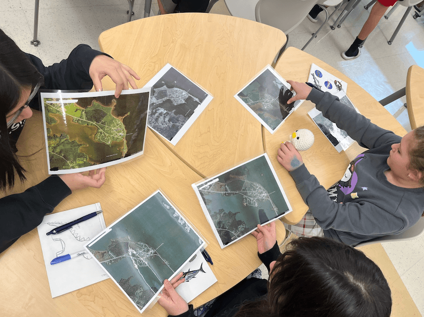
Fifth-grade students at the Sipayik (Pleasant Point Passamaquoddy) Reservation in Downeast Maine are investigating local coastal erosion by combining NASA satellite imagery, field surveys, and tribal elder oral histories. Supported by NASA's Science Activation program, the five-week curriculum merges Western science with Indigenous knowledge, and students are scheduled to present their findings at the Gulf of Maine Research Institute in June 2026.
Highlights
- Nine fifth-grade students at Sipayik Elementary School (Downeast Maine) completed a five-week coastal erosion curriculum in March 2025, supported by NASA's Science Activation program.
- The project combined NASA satellite imagery from 1942–2023 with Passamaquoddy elder oral histories to measure and document shoreline change over decades.
- Students traveled 3.5 hours to present their research at the Gulf of Maine Research Institute in June 2026, impressing scientists and REU interns with their command of NASA imagery analysis.
- Future project phases will expand elder participation, deepen Passamaquoddy language and cultural ties, and support tribal-led coastal resilience planning including wetland restoration.
- The initiative models a replicable framework for merging Indigenous Traditional Knowledge with satellite-based remote sensing in community environmental education.
By Keri Moskowitz / Gulf of Maine Research Institute
For the people of the Pleasant Point Passamaquoddy Reservation in Downeast Maine—known to its inhabitants as Sipayik—the sea has always been a teacher. Situated on Passamaquoddy Bay, generations of Indigenous community members have lived by the rhythms of the tides, the land, and the wisdom of their elders. Today, however, the shoreline is changing at an unprecedented pace, as erosion quietly reclaims land steeped in deep historical memory.
Origins: From an Alaska Workshop to a Maine Classroom
In the summer of 2023, the Learning Ecosystems Northeast (LENE) team—part of NASA's Science Activation (SciAct) program—attended a "Climate Change in My Community" workshop in Fairbanks, Alaska, hosted by the SciAct-affiliated Arctic and Earth Signs project. That experience sparked a collaboration with Indigenous leaders and scientists to explore a central question: What does coastal erosion mean for people who have already lost so much land?
The project formally launched at Sipayik Elementary School in November 2024, with the goal of integrating Western science and Indigenous knowledge to help students understand environmental change happening in their own community.
Five Weeks of Learning: Satellite Imagery, Field Surveys, and Elder Wisdom
The curriculum ran through March 2025. Over five weeks, nine fifth-grade students explored coastal erosion through multiple lenses:
- Field investigations: Walking the local shoreline while listening to elders describe how the coast once looked.
- Historical measurement: Using elder accounts as reference points to measure shoreline change on-site and on classroom maps.
- Hands-on experiments: Building simple erosion tanks to simulate how waves shape landforms.
- Tidal comparison: Measuring current high-tide lines and comparing them against historical records.
- Image analysis: Examining historical photographs and aerial imagery spanning 1942 to 2023 to track shoreline migration.
- Map overlay: Comparing 300-year-old tribal maps with future flood-projection maps.
Through the process, students came to understand that science is not confined to textbooks. As one observer reflected: "Our ancestors didn't go to school, and they were already scientists."
Presenting to Scientists: A 3.5-Hour Drive Well Worth It
In June 2026, the students were invited to present their research at the Gulf of Maine Research Institute, sharing findings with scientists, researchers, and Research Experience for Undergraduates (REU) interns. The group made the 3.5-hour drive to Portland, and the results were striking.
During the Q&A session, when an audience member asked whether reading the various maps had been difficult, one student was quick to correct the framing: "Those aren't just regular maps—they're NASA satellite images." The exchange captured both the depth of what the students had learned and the pride they took in their work.
Looking Ahead: Cultural Continuity and Coastal Resilience
Future plans for the project include engaging more elders, expanding field survey sites, deepening connections to Passamaquoddy language and culture, sharing outcomes with other Indigenous youth, and working alongside tribal leadership to develop coastal resilience strategies such as wetland restoration.
When students were asked whether they wanted to continue the research and advocacy after the course ended, every single one answered: "Yes."
In Sipayik, the story of erosion has never been only about land loss. It is also about memory, knowledge, identity, and a resilient community that continues to learn from its coastline—and has never stopped adapting.
原文來源: 查看原文
FAQ
Newsletter
Subscribe to our Low-Altitude Industry Newsletter
Daily curated news on low-altitude economy and drone industry, delivered to your inbox.
Reviewed and published by the LAETimes editorial desk ·


