SouthPAN Satellite Service Significantly Boosts Drone Survey Accuracy for New Zealand Forestry
The SouthPAN satellite-based augmentation service is enabling New Zealand's Bioeconomy Science Institute to collect forestry data faster and with greater precision. By delivering real-time GNSS correction signals across the South Pacific, SouthPAN reduces positioning errors and streamlines drone-based field operations, cutting the need for ground control points and post-processing work.
Highlights
- SouthPAN is a satellite-based augmentation service (SBAS) jointly developed by Australia and New Zealand to enhance GNSS accuracy across the South Pacific.
- New Zealand's Bioeconomy Science Institute has integrated SouthPAN into forestry drone surveys, reporting significant gains in positional accuracy and data-collection efficiency.
- SouthPAN's real-time correction signals reduce the number of ground control points required, lowering operational costs and post-processing labour for drone survey missions.
- Higher-accuracy tree-location data enabled by SouthPAN supports improved carbon-stock calculations, resource estimation, and sustainable harvest planning in New Zealand forests.
- As SouthPAN expands, broader agricultural, forestry, and geospatial applications across New Zealand and Australia are expected to benefit from the enhanced positioning service.
SouthPAN — the Southern Positioning Augmentation Network jointly developed by Australia and New Zealand — is delivering a step-change in precision for New Zealand's forestry sector, enabling the Bioeconomy Science Institute to gather large volumes of field data more quickly and accurately than ever before.
What Is SouthPAN?
SouthPAN is a satellite-based augmentation service (SBAS) co-developed by Australia and New Zealand to provide enhanced GNSS (Global Navigation Satellite System) positioning signals across a broad swathe of the South Pacific. The system significantly reduces positioning errors, making it particularly valuable for applications that demand high-accuracy spatial data — including agriculture, forestry, infrastructure inspection, and drone operations.
A Breakthrough for Forestry Applications
Since integrating SouthPAN technology into its New Zealand forestry inventory and monitoring workflows, the Bioeconomy Science Institute has reported measurable improvements in both data-collection efficiency and positional accuracy. Previously, forestry surveyors were constrained by the limitations of conventional GNSS, requiring extensive post-processing corrections. SouthPAN's real-time correction signals have streamlined field operations considerably.
The accuracy gains carry significant implications for forest management. More precise tree-location data supports improved resource estimation, carbon-stock calculations, and harvest planning — all of which underpin sustainable forestry management objectives.
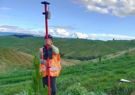
Impact on Drone Operations
Combining drone aerial surveys with SouthPAN's high-accuracy positioning allows researchers to cover larger areas in the same amount of time while reducing the number of ground control points (GCPs) needed for post-processing. The result is a meaningful reduction in overall operational costs and labour requirements.
As SouthPAN continues to expand and mature, a growing number of agricultural, forestry, and geospatial applications across New Zealand and Australia are expected to benefit from the technology.
原文來源: 查看原文
FAQ
Newsletter
Subscribe to our Low-Altitude Industry Newsletter
Daily curated news on low-altitude economy and drone industry, delivered to your inbox.
Reviewed and published by the LAETimes editorial desk ·