Xer Technologies and YellowScan Partner to Deliver Long-Endurance Bathymetric and Underwater Survey Solutions
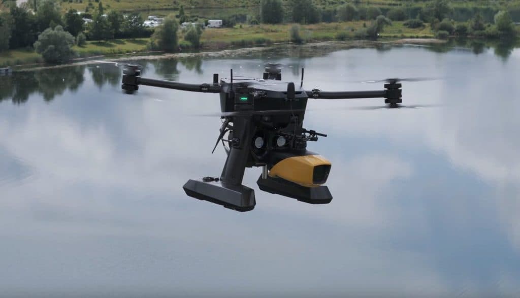
Swiss drone manufacturer Xer Technologies and French UAV LiDAR specialist YellowScan announced on July 30, 2024, the successful integration of the YellowScan Navigator bathymetric system onto the Xer X8 drone platform. Powered by hybrid-electric technology, the Xer X8 offers over 2.5 hours of flight endurance with a 7 kg payload capacity, enabling efficient underwater terrain mapping for environmental monitoring, coastal management, and infrastructure development.
Highlights
- Xer Technologies and YellowScan announced on July 30, 2024, the integration of the YellowScan Navigator bathymetric LiDAR system onto the Xer X8 drone platform.
- The Xer X8 hybrid-electric drone achieves over 2.5 hours of flight endurance with a maximum payload capacity of 7 kg, enabling large-area surveys in a single flight.
- The YellowScan Navigator uses green-laser LiDAR technology to deliver high-resolution, high-accuracy underwater terrain data for bathymetric surveys.
- The integrated solution targets applications in environmental monitoring, coastal management, and infrastructure development, addressing industries that rely on accurate bathymetric data.
- The Xer X8 is ready for take-off within 2 minutes and can operate in adverse weather conditions, making it practical for demanding field deployments.
Montpellier, France / Dietikon, Switzerland — July 30, 2024
Drone technology pioneer Xer Technologies and UAV LiDAR solutions leader YellowScan have announced the successful integration of the YellowScan Navigator bathymetric system onto the Xer Technologies drone platform, delivering unprecedented long-endurance underwater terrain mapping and inspection capabilities.
The integration combines the core strengths of both companies. Xer Technologies' advanced long-endurance, high-payload drone platform now supports YellowScan's latest green-laser LiDAR technology, offering a unique all-in-one, long-range solution for underwater topographic mapping. Bathymetry — the study of underwater terrain — is critical to industries including environmental monitoring, coastal management, and infrastructure development.
Key Features of the Integrated System
- Advanced Bathymetric Capability: Delivers high-resolution, high-accuracy bathymetric data even in complex aquatic environments.
- Extended Flight Endurance: The Xer Technologies drone can operate for more than 2 hours in demanding conditions, covering larger areas in a single flight and significantly improving survey efficiency.
- Comprehensive Data Collection: Ensures seamless data acquisition, processing, and analysis, providing users with reliable and actionable insights.
Overcoming the Endurance Limitations of Conventional Drones
UAV bathymetric LiDAR operations typically require take-off from locations far from the target area — such as vessels or shorelines. Conventional electric drones often suffer from severely limited flight times when carrying high-end payloads like the Navigator. The Xer X8 drone addresses this challenge directly, offering more than 2 hours of flight time to ensure consistent, user-friendly, and efficient performance in high-demand scenarios — making it an ideal platform for bathymetric LiDAR applications.
Partner Statements
Roberto Casini, OEM Business Unit Manager at YellowScan, said: "We are thrilled to collaborate with Xer Technologies to integrate the YellowScan Navigator system onto their advanced drone platform. This partnership is a significant milestone in our mission to deliver cutting-edge UAV LiDAR solutions. By combining our expertise in high-resolution bathymetric LiDAR technology with Xer's innovative drone capabilities, we are offering a powerful tool for underwater topographic mapping. This joint product will enhance the efficiency and accuracy of bathymetric surveys, supporting critical applications in environmental monitoring, coastal management, and infrastructure development."
Gökmen Çetin, International Sales Manager at Xer Technologies, said: "Partnering with YellowScan to integrate their Navigator bathymetric system onto our drone platform is a major milestone for Xer Technologies, bringing new state-of-the-art capabilities to the market. Our commitment to pushing the boundaries of drone technology aligns perfectly with YellowScan's leadership in UAV LiDAR solutions. This collaboration allows us to offer high-performance underwater topographic mapping solutions that meet the needs of various industries with greater precision and efficiency."
About Xer Technologies
Xer Technologies AG, headquartered in Switzerland, focuses on the development, production, and marketing of customizable, heavy-lift unmanned aircraft systems (UAS). The company helps clients extract actionable insights from data to drive a safer, more efficient, and more sustainable world. The Xer X8 drone features a unique hybrid-electric powertrain, is ready for take-off within 2 minutes, carries payloads of up to 7 kg, and can fly for up to 2.5 hours even in adverse weather conditions. For more information, visit: www.xer-tech.com
About YellowScan
YellowScan designs, develops, and manufactures LiDAR solutions for professionals who demand high performance, reliability, and precision. Its hardware and software products are easy-to-use data collection tools, backed by expert training and technical support. Each system integrates a laser scanner, inertial navigation system (INS), GNSS receiver, and onboard computing unit to meet the highest standards of 3D mapping accuracy.
Founded in 2012 in southern France, YellowScan has sales, customer training, and technical support representatives worldwide. Its products are used across a wide range of fields including surveying and mapping, bathymetry, forestry, environmental research, archaeology, civil engineering, and mining.
原文來源: 查看原文
FAQ
Newsletter
Subscribe to our Low-Altitude Industry Newsletter
Daily curated news on low-altitude economy and drone industry, delivered to your inbox.
Reviewed and published by the LAETimes editorial desk ·


