Dominion Energy Deploys 50-Drone Fleet Across U.S. Power Grid, Building Comprehensive Inspection Infrastructure
Dominion Energy has established a drone inspection program centered on a 50-platform fleet — including flying, walking, crawling, and diving units — supported by 23 autonomous 'drone-in-a-box' remote operation stations. Ten FAA-licensed pilots have already logged more than 10,000 miles of infrastructure inspections with BVLOS authorization, dramatically improving fault detection efficiency across the utility's service territory.
Highlights
- Dominion Energy operates 50 drone platforms spanning flying, walking, crawling, and diving types, managed by 10 FAA-certified pilots who have logged over 10,000 miles of grid inspections.
- The company has deployed 23 autonomous drone-in-a-box stations at substations across its multi-state service territory, each enabling cellular-linked BVLOS operations authorized by the FAA.
- A thermal imaging drone scan of a 142 MW solar farm in Surry County, Virginia identified a fault location within approximately 10 minutes of flight time — a task that would require walking 130 rows of panels on foot.
- The largest platform in the fleet is a 6-foot VTOL fixed-wing drone cruising at 45 mph (72 km/h) with onboard LiDAR for point-cloud navigation and vegetation-penetrating ground clearance measurement.
- The identity of the drone manufacturers supplying Dominion's BVLOS fleet has not been publicly disclosed, raising questions given current U.S. regulatory scrutiny of Chinese-made drones over critical infrastructure.
In June, when Dominion Energy grid operators noticed an unusual power drop at the Colonial Trail West solar farm in Surry County, Virginia, they didn't dispatch a line technician — they sent a drone.
Pilot Aaron Colgrove pulled up the mission from Dominion's D-ROC (Drone Remote Operations Center), directed the drone to the northwest corner of the 142-megawatt solar farm located 50 miles (80 km) away, and let it execute the task autonomously.
The drone flew a lawnmower-pattern route, systematically scanning 130 rows of solar panels — each between 300 and 500 feet (91–152 meters) long. Colgrove monitored two screens: a color camera to confirm the surrounding airspace on approach, then a switch to thermal imaging once the drone entered the farm.
Ten minutes later, he had his answer. At the north end of the third row, a cluster of roughly a dozen bright white rectangles appeared clearly — panels running too hot to generate power. The fault location was immediately obvious, with no need to put boots on the ground. That is what a mature utility drone program looks like in practice.
23 Drone-in-a-Box Stations Deployed Across the Grid
According to The Virginian-Pilot, Dominion's Unmanned Systems Group has installed 23 drone-in-a-box units — gray, tripod-mounted cabinets — at substations and facilities throughout its service territory. Each unit is entirely self-contained.
Drones charge inside the box, automatically receive weather and airspace data, and connect to pilots via onboard cellular communications. That cellular link is critical: the FAA has authorized Dominion to fly these systems beyond visual line of sight (BVLOS), meaning Colgrove can conduct a full scan of the solar farm from an operations center far from Surry County.
Having launch pads in place and holding BVLOS authorization represents a significant time-and-resource advantage for the Unmanned Systems Group.
The group employs 10 FAA-certified pilots who have collectively logged more than 5,000 flight hours and inspected over 10,000 miles of Dominion's lines and facilities. Every pilot is qualified to operate any platform in the fleet — a total of 50 platforms spanning flying, walking, crawling, and diving variants. Pilots select the best unit for each mission based on battery life, payload capacity, airspeed, sensor options, and obstacle avoidance capability.
A Diverse Fleet Built for Every Inspection Scenario
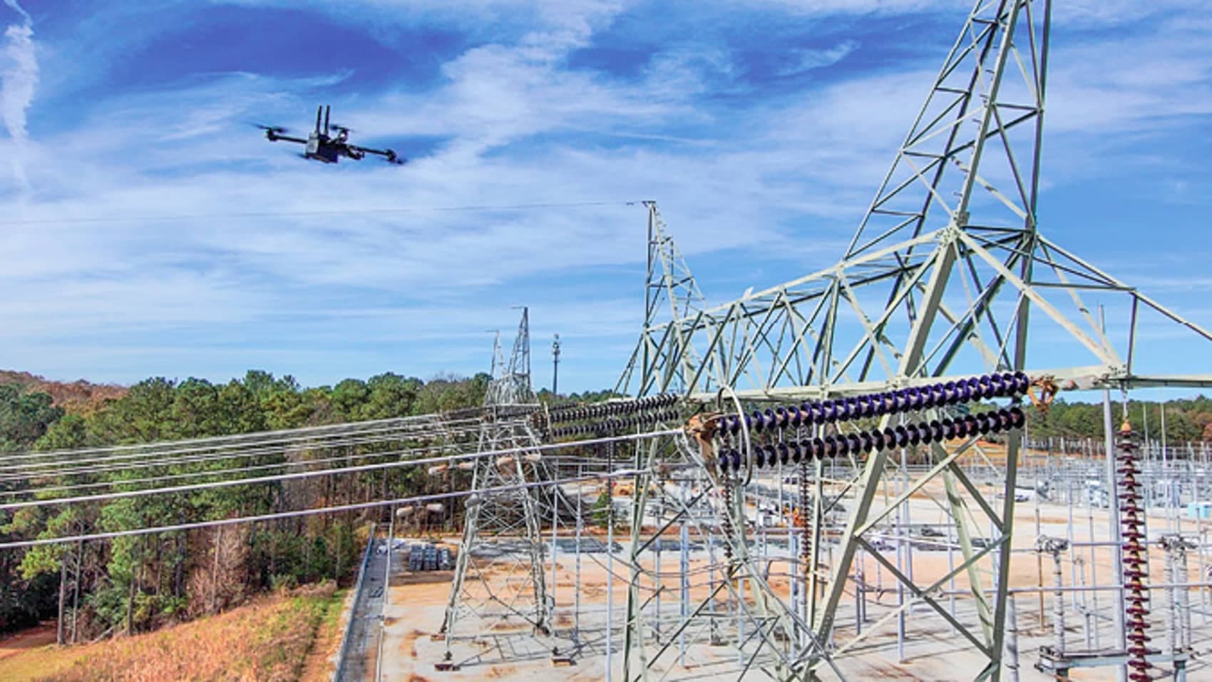
The largest platform in the fleet is a roughly 6-foot (1.8-meter) vertical take-off and landing (VTOL) fixed-wing drone capable of cruising at 45 mph (72 km/h) with BVLOS capability — though Dominion currently restricts its use to sparsely populated areas, such as transmission corridors cutting through forested terrain in western Virginia. At that speed, a single pilot can inspect miles of high-voltage lines in a fraction of the time previously required.
Rather than relying on cameras alone, the VTOL navigates within a point-cloud environment — an onboard LiDAR laser continuously scans for obstacles and precisely tracks the position of power lines below. LiDAR measures the exact clearance between wires and the ground and, critically, can penetrate vegetation to detect soil erosion that may be undermining pole or tower foundations. Unmanned Systems Group director T.F. Butler put the capability gap bluntly: "That's the difference between the view at 200 feet versus 700 feet — and the latter is just a blurry phone photo." It is the difference between a line worker walking beneath the wires and a drone carrying an actual data sensor suite.
For close-range precision inspections, pilots switch to a smaller black quadcopter suited for approaching specific structures, assessing clearances, and pausing for manual input before final approach. Pilot Joel Cashman can fly it directly over the top of a pole, capture shots from all four cardinal directions, and maneuver beneath the hardware. "You can count the threads on a bolt and tell if it's backing off — you can't see that from the ground," Butler said.
The fleet also includes underwater drones for inspecting tower foundations and submerged cables beneath rivers and streams. As Dominion advances its offshore wind project — currently under construction in the Atlantic Ocean 25 miles (40 km) off Virginia Beach — this capability will become increasingly valuable. A walking drone called "Odie" handles post-hurricane damage assessments in terrain made inaccessible to personnel by downed trees and energized fallen lines.
Thermal Imaging Turns Electrical Anomalies Into Solvable Problems
When Colgrove switched to thermal mode over Colonial Trail West, he was looking for a specific heat signature. A solar panel running warmer than ambient temperature has stopped converting sunlight into electricity. Scattered white dots across the array — individual overheated diodes — were not the concern; the dense band of bright white rectangles at the north end of row three told him precisely where the generation loss was concentrated.
The entire diagnostic workflow — grid operator flags the anomaly, D-ROC schedules the mission, pilot executes the thermal scan, problem confirmed — took roughly ten minutes of actual flight time. Walking 130 rows of panels, each up to 500 feet (152 meters) long, is not remotely comparable in efficiency.
Industry Perspective
What Dominion has built is an in-house drone operation with platform diversity that surpasses most commercial operators. Walking drones, diving drones, BVLOS-certified VTOL fixed-wings, a drone-in-a-box BVLOS network spanning a multi-state grid — this is no longer an inspection aid; it is a parallel maintenance force with a distinct risk profile.
After years of tracking utility drone programs, the most striking detail is the FAA's cellular BVLOS authorization covering all 23 box units. For most commercial operators, FAA BVLOS approval remains a case-by-case, time-intensive process. Dominion's box network has turned what most programs are still trialing with a handful of platforms into actual operational infrastructure.
Other utilities seeing Dominion's 23-unit network will inevitably want to replicate it. But the question no one is asking is: what does a program at this scale actually cost to build and maintain? Ten pilots, 50 platforms, FAA BVLOS authorization across a multi-state footprint — this isn't a drone budget line item; it is an aviation department.
One detail absent from the reporting deserves attention: which drone manufacturers supply those 23 boxes? Given the current regulatory environment surrounding Chinese-manufactured drones flying over U.S. critical infrastructure, the identity of the manufacturers behind Dominion's BVLOS fleet is consequential — and it has not been disclosed, though it should be.
Image credits: Dominion Energy Virginia; Vanderbilt University
原文來源: 查看原文
FAQ
Newsletter
Subscribe to our Low-Altitude Industry Newsletter
Daily curated news on low-altitude economy and drone industry, delivered to your inbox.
Reviewed and published by the LAETimes editorial desk ·