Droniq Maps Rebrands as TraX: Germany's Next-Generation Drone Management App Goes Live
German drone airspace services provider Droniq has relaunched its Droniq Maps application under the new name TraX, focusing on airspace safety, flight overview, and visibility. The app supports flight validation, real-time airspace status, weather data, and flight logging. Three subscription tiers are available — a free version, TraX Plus, and TraX Pro — and the app is now live on both the Apple App Store and Google Play Store.
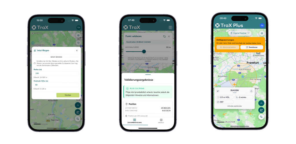
Highlights
- Droniq has replaced its Droniq Maps application with TraX, a rebranded next-generation drone management app designed for the German market.
- TraX is available in three tiers — free, TraX Plus, and TraX Pro — with real-time airspace status and alert features restricted to paid plans.
- Core features include flight validation, a "Fly Now" airspace visibility function, weather integration, flight logging, and geofence map overlays.
- Existing Droniq Maps data will not be migrated to TraX, and users must complete a new streamlined registration process.
- TraX is now live on both the Apple App Store and Google Play Store and can be used in a limited capacity without logging in.
Droniq Maps Officially Rebrands as TraX
German drone airspace management services provider Droniq has announced the launch of TraX, its next-generation drone application, replacing the existing Droniq Maps platform. Built around the core principles of safety, airspace overview, and flight visibility, TraX is designed to comprehensively enhance the operational experience for drone pilots in Germany.
For existing Droniq Maps users, the transition means a new application, a new brand name, and a systematic upgrade tailored to the demands of modern drone operations.
What Is TraX?
TraX is a drone management application built specifically for the German market. It helps drone pilots safely plan missions, quickly validate flight conditions, and make their flight activity visible to other airspace users — improving overall airspace transparency.
Through TraX, pilots can immediately see:
- Permitted flight areas and relevant advisories
- Applicable conditions and regulatory restrictions
- Real-time airspace activity in the surrounding area
Why TraX?
As airspace grows increasingly complex, the requirements for safe and compliant flight continue to rise. TraX addresses this need by embracing the core principle of "see and be seen":
- Enhanced overall airspace situational awareness
- Rapid mission compliance validation
- Improved drone flight visibility within shared airspace
This framework provides pilots with clear decision-making support both before and during flight.
Key Features
Flight Validation Confirm on-site whether a flight is permissible and which regulations apply. All critical information is presented in a clear, accessible format.
"Fly Now" Feature — Airspace Visibility Activating the "Fly Now" feature makes your active flight area visible to other airspace users, supporting shared situational awareness and improving overall flight safety.
Real-Time Airspace Status * Monitor the airspace around your mission in real time for a comprehensive situational picture.
Warnings and Alerts * Receive instant notifications about significant airspace developments — such as unexpected intrusions — enabling early response.
Weather Information Integrated weather data helps pilots make informed flight decisions.
Flight Log Conveniently record each drone flight directly within the app.
Geofences and Map Overlays All relevant geozones, active flight areas, and model aircraft airfields are displayed directly on the map.
* Real-time airspace status and warning features are available exclusively on TraX Plus and TraX Pro plans.
What Droniq Maps Users Need to Know
With the move to TraX, the original Droniq Maps application will be replaced. Key points:
- The app will update automatically, or can be manually downloaded from the Google Play Store or Apple App Store
- TraX requires a streamlined new registration process
- Existing Droniq Maps data will not be migrated to TraX
- TraX can also be used without logging in, though features will be limited
TraX: Greater Clarity, Greater Safety
TraX aims to make drone operations simpler, safer, and more transparent. Whether for recreational pilots or professional users, TraX helps operators gain a deeper understanding of airspace conditions — laying the foundation for safe flight.
Download TraX Now
TraX is now officially available on the Apple App Store and Google Play Store. For more information, visit the Droniq official website.
Background
With drone traffic steadily increasing and airspace transparency still lacking, low-altitude airspace has gradually become a safety-sensitive zone. Droniq addresses this issue in greater depth in its latest release, "Why Low-Altitude Airspace Visibility Is Becoming Increasingly Important."
原文來源: 查看原文
FAQ
Newsletter
Subscribe to our Low-Altitude Industry Newsletter
Daily curated news on low-altitude economy and drone industry, delivered to your inbox.
Reviewed and published by the LAETimes editorial desk ·


