Voliro's B-Scan Payload Brings Corrosion Mapping to Drone-Based NDT
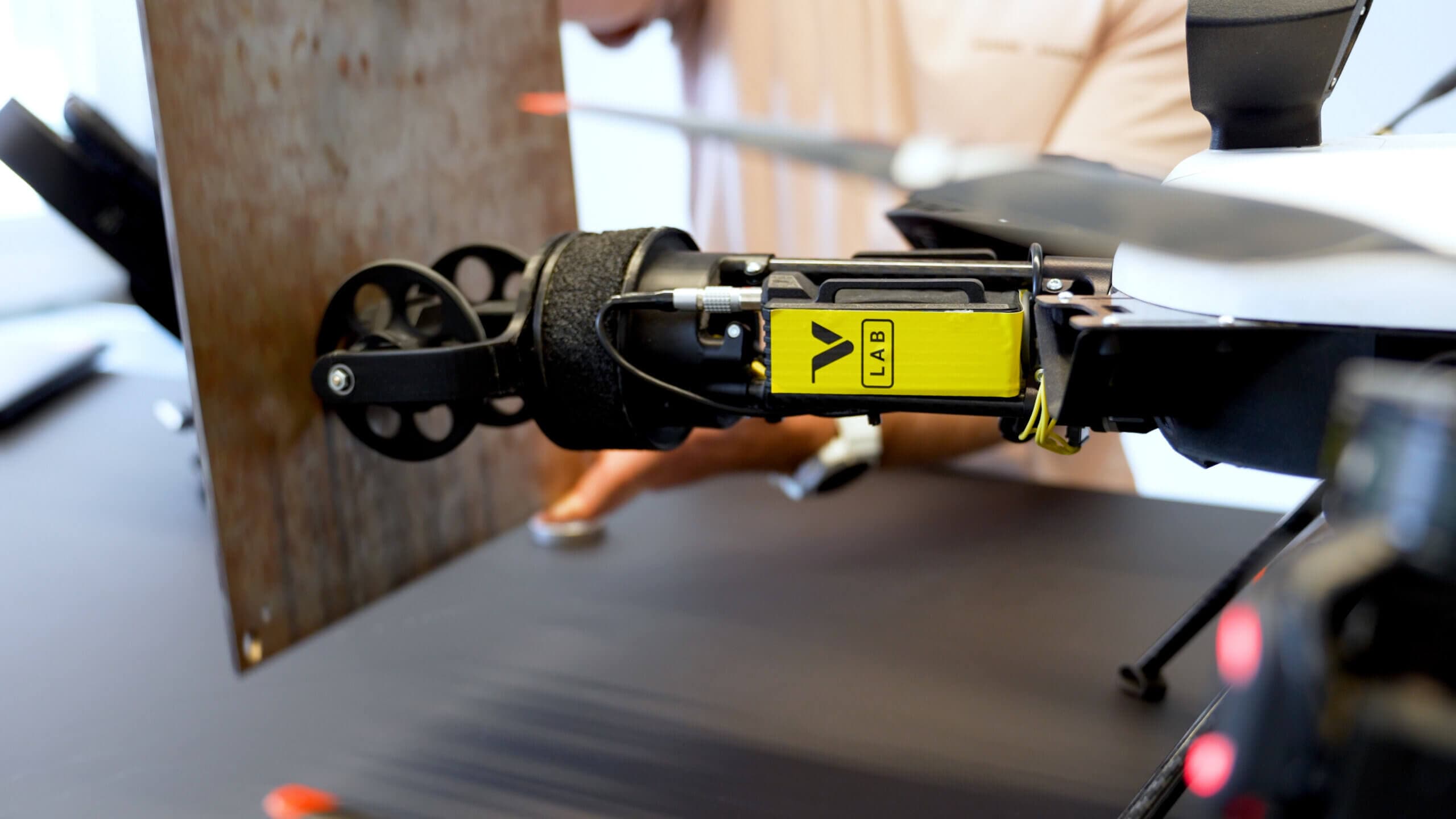
Voliro has introduced a roller-contact B-Scan payload for its Voliro T drone platform, capable of collecting tens of thousands of thickness measurements per hour. The system delivers full B-Scan waterfall records and real-time thickness data, vastly outperforming traditional rope-access or scaffolding methods while reducing the need for personnel to work at height.
Highlights
- Voliro's B-Scan roller payload collects tens of thousands of ultrasonic thickness measurements per hour on the Voliro T drone platform, compared to over 100 per hour with conventional point-measurement NDT.
- The encoder-wheel system maintains continuous surface contact during flight, generating full B-Scan waterfall records and real-time thickness data geo-referenced to the drone's onboard positioning system.
- Data uploads directly to Voliro Cloud with no additional processing, producing audit-ready inspection reports suitable for fitness-for-service assessments and remaining-life calculations.
- The B-Scan payload requires no changes to existing Voliro T hardware, pilot training, or operating procedures.
- Voliro's NDT roadmap includes UT arrays, phased-array ultrasonic systems, and CUI mapping; the technology is currently in early prototype stage and seeking field validation partners.
Voliro's B-Scan Payload Brings Corrosion Mapping to Drone-Based NDT
In existing aerial non-destructive testing (NDT) workflows, skilled crews operating the Voliro T can collect more than 100 thickness measurements per hour — already a significant improvement over conventional rope-access or scaffolding-based inspections.
What B-Scan Changes
Voliro's new B-Scan roller payload uses an encoder-wheel system that maintains continuous surface contact as the drone travels along a structure. The results are striking: tens of thousands of measurements per hour, complete B-Scan waterfall records, and real-time thickness data.
Same Platform, Expanded NDT Capability
For existing Voliro T operators, the workflow remains unchanged — same drone, same pilot, same operating method — with scanning capability added on top. The practical implications, however, are significant:
-
Full-area coverage: Continuous scanning eliminates blind spots between measurement points. For assets with known or suspected general corrosion, inspection coverage can now genuinely reflect the asset's actual condition rather than a statistically estimated sample.
-
Defect sizing, not just detection: While point measurements confirm wall-thickness loss at a specific location, B-Scan data maps the full extent of that loss — how far corrosion has spread laterally and how depth varies across the affected area. This is precisely the information required for fitness-for-service assessments and remaining-life calculations.
-
Audit-ready documentation: B-Scan waterfall images, thickness grids, and positional data are generated in real time during the flight and geo-referenced to Voliro's onboard positioning system. The output is a complete, auditable inspection record that can be reviewed, adjusted, and uploaded directly to Voliro Cloud — no additional processing steps needed to integrate it into reporting workflows.
-
Reduced reliance on at-height personnel: Corrosion mapping at the resolution achievable with aerial B-Scan has historically required direct physical access — rope-access teams, scaffolding, or dedicated crawler systems. The Voliro T is progressively eliminating these dependencies across a growing range of asset types, including curved structures, in-service assets, and elevated components.
What Comes Next
The Voliro B-Scan roller payload is the first step in a broader scanning strategy for the Voliro T platform. UT arrays, phased-array ultrasonic systems, and corrosion-under-insulation (CUI) mapping are all on the technology roadmap, each building on the same roller-contact capability. For Voliro T operators, the platform they fly today is the one that will carry all of these capabilities in the future.
The technology is currently in early prototype stage, and Voliro is actively seeking Voliro T operators and asset owners to participate in field validation. If you manage critical infrastructure and want to be among the first to test this technology on your own assets, reach out to Voliro.
原文來源: 查看原文
FAQ
Newsletter
Subscribe to our Low-Altitude Industry Newsletter
Daily curated news on low-altitude economy and drone industry, delivered to your inbox.
Reviewed and published by the LAETimes editorial desk ·


