BRINC Drones and Nova Software Company Partner to Deliver Advanced Aerial Mapping Capabilities to Public Safety Agencies
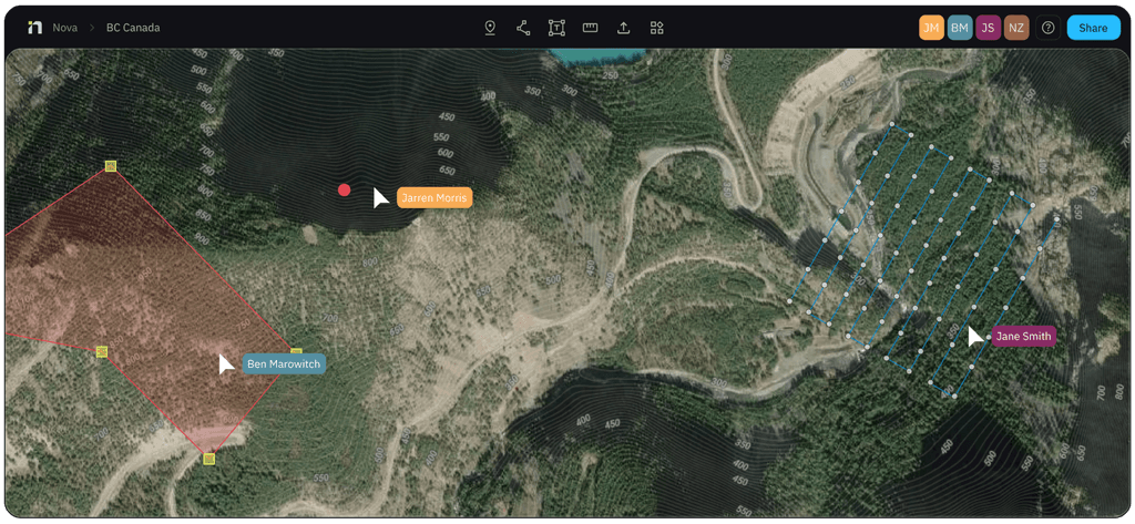
BRINC, a leading U.S. public safety drone manufacturer, and Nova Software Company, an aerial mapping and data analytics software provider, have announced a strategic partnership. The integration allows first responders to execute mapping missions via BRINC LiveOps and upload imagery to Nova for real-time hotspot detection and data analysis—no additional hardware required. Combined with the dual radiometric thermal cameras on BRINC's next-generation Guardian drone, the partnership aims to deliver the most powerful thermal mapping solution ever available to public safety agencies.

Highlights
- BRINC and Nova Software Company announced a strategic partnership on June 24, 2026, to deliver integrated aerial mapping and real-time hotspot detection for public safety first responders.
- The integration works within the existing BRINC LiveOps platform, allowing agencies already using the BRINC Responder to access Nova's data analytics capabilities with no new hardware required.
- BRINC's next-generation Guardian drone features dual radiometric HD thermal cameras that, combined with Nova's software, deliver what the companies describe as the most powerful thermal mapping solution in public safety history.
- Over 900 U.S. public safety agencies and more than 20% of SWAT teams currently deploy BRINC drone technology for crisis mitigation operations.
- Nova's platform provides real-time streaming, hotspot detection, panoramic imagery, live collaboration, and advanced data analytics, serving public safety agencies and emergency management teams across North America.
BRINC Drones and Nova Software Company Partner to Deliver Advanced Aerial Mapping Capabilities to Public Safety Agencies
Real-Time Aerial Intelligence Integrates Automated Mapping and Hotspot Detection to Enhance First Responder Capabilities
Seattle, Washington, June 24, 2026 — BRINC, a leading U.S. developer of drone technology for public safety, and Nova Software Company, a software firm providing aerial mapping and data analytics capabilities purpose-built for public safety, today announced a strategic partnership to bring advanced aerial mapping and data analysis functionality to first responders.
The integration enables public safety agencies to transform drone imagery captured on the BRINC platform into actionable intelligence, giving incident commanders the situational awareness needed to coordinate emergency response operations on scene.
Available Immediately—No Additional Hardware Required
Public safety agencies that have already deployed the BRINC Responder can access this integration today. Operators can configure mapping missions through BRINC LiveOps, capture aerial imagery, and upload data directly to Nova for processing—all without procuring new hardware. The result is professional-grade operational mapping that combines cartographic output, data analytics, and real-time intelligence to accelerate coordination, improve on-scene situational clarity, and support better decision-making for personnel in the field.
The integration has been designed with operational continuity in mind: agencies can invest in software workflows from day one, and those same workflows remain in place as hardware evolves.
"Fire departments, law enforcement agencies, and emergency response teams are operating in increasingly complex and dangerous environments," said Blake Resnick, Founder and CEO of BRINC. "Our partnership with Nova gives our customers an immediate upgrade in how they understand and respond to critical incidents. And now, with Guardian, we've built the most powerful thermal mapping solution in the history of public safety."
Guardian: Next-Generation Drone Brings New Thermal Intelligence
The full potential of this partnership is realized with Guardian, BRINC's next-generation drone. Guardian is equipped with two radiometric high-definition thermal cameras engineered specifically for public safety applications. Combined with Nova's processing software, Guardian enables real-time thermal map generation and advanced data analytics—precisely identifying hotspots, tracking how situations evolve on the ground, and delivering the thermal intelligence public safety teams need to prevent escalation and coordinate safe operations.
"Partnering with BRINC puts the Nova platform directly into the hands of agencies already in the field saving lives," said Robert Atwood, CEO of Nova Software Company. "BRINC's operational platform paired with Nova's aerial intelligence software means incident commanders get more accurate information faster—and that translates directly into safer response outcomes."
An End-to-End Complete Solution
Together, BRINC and Nova offer a complete end-to-end aerial mapping and intelligence solution encompassing hardware purpose-built for public safety, an integrated operational platform, and powerful data analytics software designed for the real-world demands of emergency response.
Interested agencies can contact their local BRINC sales representative or schedule a demonstration at: https://brincdrones.com/contact/
About BRINC
BRINC is a U.S. technology developer serving the public safety sector, dedicated to building an ecosystem of connected tools with the mission of saving lives. BRINC manufactures its products domestically, co-locating R&D and production, and maintains a vertically integrated supply chain. More than 900 public safety agencies across the United States—including over 20% of SWAT teams—use BRINC products for crisis mitigation operations. The company is backed by top-tier investors including Sam Altman, Index Ventures, Motorola Solutions, Dylan Field, Elad Gil, Patrick Shanahan, Julius Genachowski, Shyam Sankar, Alexandr Wang, Bradley Tusk, and Jeff Weiner. Learn more at brincdrones.com.
About Nova Software Company
Nova is a public safety intelligence platform built for frontline critical decision-makers. Going far beyond traditional mapping, Nova delivers real-time streaming, hotspot detection, panoramic imagery, live collaboration, and advanced data analytics—transforming raw drone footage into actionable intelligence. Whether supporting fire response, law enforcement operations, search and rescue, or emergency management, Nova provides field teams and incident commanders with a comprehensive aerial intelligence solution. Nova serves public safety agencies, emergency management teams, and enterprise clients across North America. Learn more at mapnova.com.
原文來源: 查看原文
FAQ
Newsletter
Subscribe to our Low-Altitude Industry Newsletter
Daily curated news on low-altitude economy and drone industry, delivered to your inbox.
Reviewed and published by the LAETimes editorial desk ·