大疆 Matrice 300 RTK 熱成像無人機協助發現 Clarkson 公寓火災隱藏熱點
紐約州 Clarkson 一棟三層公寓發生火災,火勢迅速蔓延至閣樓。Monroe 縣警長辦公室出動搭載熱成像設備的 DJI Matrice 300 RTK,從空中即時偵測隱藏熱點,使消防員無需進入結構不穩的閣樓即可掌握火情,成功提升救災安全性與效率,最終30名居民被迫撤離,4人在現場接受救治。
文章重點
- Monroe 縣警長辦公室出動 DJI Matrice 300 RTK 搭載熱成像設備,從空中即時偵測 Clarkson 公寓三層閣樓的隱藏火源熱點。
- Clarkson 公寓閣樓無防火牆、無灑水系統,火勢迅速蔓延導致整個天花板崩塌,造成30人撤離、4人受傷。
- 熱成像無人機讓消防員無需進入結構不穩的閣樓,即可掌握火勢分布,同時提升救災安全性與效率。
- Monroe 縣警長辦公室配置三名 FAA 認證遠端飛行員,確保無人機可在緊急狀況下即時出勤,不受排班限制。
- DJI Matrice 300 RTK 除熱成像外,亦可搭載 LiDAR 感測器進行三維建模,支援火災調查與場景重建。
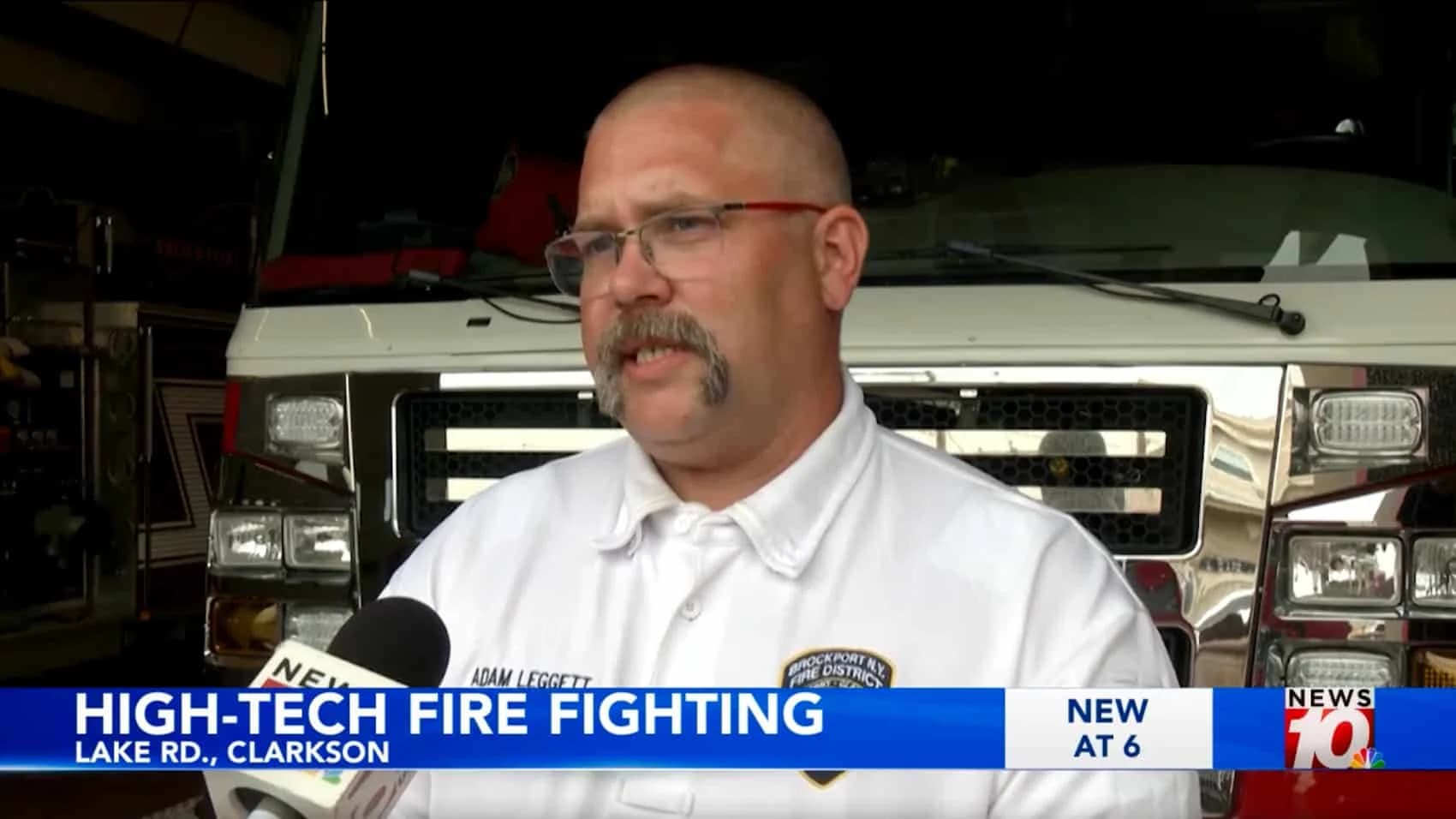
紐約州 Clarkson 市一棟靠近 SUNY Brockport 大學的三層公寓發生火災,火勢蔓延速度遠超消防人員預期,迅速竄入閣樓空間。Brockport 消防局局長 Adam Leggett 抬頭望著建築物高度,意識到地面人員根本看不到一半以上的火源熱點,Monroe 縣警長辦公室隨即出動一架搭載熱成像功能的 DJI Matrice 300 RTK。
接下來發生的事,正是各地執法單位持續投資專業級無人機設備、並讓 FAA 認證的遠端飛行員隨時待命的最佳佐證——面對不能等待傳統方式趕上的緊急狀況,無人機已成為不可或缺的第一線工具。
圖片來源:Brockport Fire
Matrice 300 RTK 偵測到的熱點,原本需要消防員攜帶手持式熱像儀爬上三樓,進入閣樓,在結構不穩的建築內搜尋火源。而現在,無人機在安全距離外將熱成像畫面即時傳回地面人員,讓消防員免於陷入幾乎已達致命風險的環境。
Monroe 縣警長辦公室無人機隊
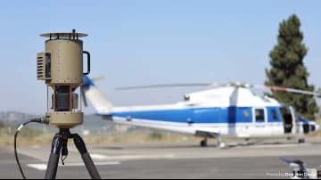
Monroe 縣警長辦公室設有一支小型無人機系統部隊,配置三名持有 FAA 執照的遠端飛行員,並運營兩架功能不同的無人機。
DJI Mavic Pro 機身輕巧,可於室內飛行,適合不需要進階感測器的快速應變任務。DJI Matrice 300 RTK 則專為複雜任務設計,例如火災熱成像偵測,或結合 LiDAR 感測器進行三維建模與場景重建。
Matrice 300 RTK 搭載高畫質相機與熱偵測設備。熱像儀能從空中讀取熱訊號,即時識別火源熱點,並將影像傳輸至地面人員,無需任何人員親身抵達現場。
該縣透過與 Monroe 縣社區規劃與參與部門的合作計畫,由縣委員會透過補充撥款採購了這套 Matrice 300 RTK 系統。同一平台也用於為 GIS 系統繪製縣有地產地圖,並支援經濟發展相關工作。
對於三層樓高的閣樓火災,Matrice 300 RTK 不只是提供便利,而是在不額外提高消防員風險的前提下,使整個救災行動得以順利進行的關鍵工具。
無人機為何改變了第一線應變模式
據 WHEC News 10 報導,Clarkson 公寓閣樓沒有設置防火牆來阻擋火勢蔓延整個天花板空間,僅有一道隔板,並非真正的防火牆。閣樓也未安裝灑水系統,這意味著一旦火勢竄入閣樓,便沒有任何機械設備能阻止它延燒整棟建築的全長。
Leggett 局長表示,即使沒有閣樓灑水系統或專用防火牆,該建築仍符合法規。這種說法聽起來合情合理,直到你親眼目睹閣樓崩塌砸入三樓那一刻。符合法規並不等於能有效阻止火勢蔓延,它只代表建築在興建時達到了最低標準,而標準並不能真實反映火勢的實際行為。
這場大火將閣樓燒得一乾二淨,整個天花板隨即崩落至下方樓層。30 名居民被迫撤離,4 人在現場接受治療,紅十字會隨後介入,協助無處可去的居民。
Leggett 局長表示無人機對整個行動至關重要時,他說的並非泛泛之詞,而是在描述一個具體問題:閣樓距地面三層樓高,且在消防人員抵達前,火勢就已蔓延至閣樓大部分空間。
消防員站在街上,可以看見建築外部的火焰,卻無法看到轉角後方、牆壁內部,或閣樓空間的水平延伸範圍。
如果你認為無人機只是在商業攝影、攝影測量、搜索救援領域帶來了改變,那你可能還不清楚它究竟改變了警察與消防部門日常作業多少。
無人機熱成像首次登上國際頭條,是在巴黎聖母院大火期間——當時熱像儀協助消防員識別出燃燒最劇烈的區域,優先集中火力進行撲救。
熱成像的優勢
熱像儀讀取的是熱訊號,而非可見光。熱點在熱成像畫面上會呈現為亮點,這讓地面人員能精確掌握火勢集中位置,而無需攀爬進不穩定的閣樓,拿著手持式熱像儀到處查找。
圖片來源:Brockport Fire
Leggett 局長直白地說明了兩種方式的取捨:替代方案是派人爬上三樓,持手持式熱成像設備在殘骸中搜尋熱點。在一棟閣樓剛剛崩塌的建築裡,這不是可以量化的風險,而是讓消防員白白送命的決定。
Matrice 300 RTK 從上方偵測出熱點,擷取熱成像影像,並即時將資訊傳回地面人員。地面消防員清楚知道應該將水柱對準哪個位置、火勢在哪裡最為活躍,完全無需任何人親身冒險進入倒塌結構。
圖片來源:Brockport Fire
Leggett 局長表示,無人機同時提升了安全性與作業效率。安全效益顯而易見;而效率的提升,意味著消防員不必浪費時間對已熄滅的區域噴水,或盲目猜測火勢的確切位置。
他們將水柱對準熱成像顯示有熱源的地方,火勢得以更快撲滅,建築燃燒的時間縮短,救災力量得以集中而非分散。
實際作業的核心
Monroe 縣警長辦公室配置三名持 FAA 執照的遠端飛行員,正是因為緊急事件不會等待任何人。電話一打進來,火災正在燃燒,建築結構已遭破壞,沒有時間討論空中熱成像是否值得一試。
一名持證飛行員搭配 Matrice 300 RTK 做出判斷,無人機升空,熱成像啟動,熱點被發現,消防員因此更加安全。
這才是唯一真正重要的考驗——不是無人機在宣傳影片中是否光鮮亮麗,而是當建築物正在燃燒時,它究竟能否挽救生命。
Matrice 300 RTK 同樣可搭載 LiDAR 感測器,建立建築物與場景的三維模型。對消防單位而言,這項功能意味著他們可以在進入建築前先完成地圖測繪,在火災後重建事發經過,並為調查工作保存完整的現場記錄。
在 Clarkson 火災現場,熱成像是最迫切的需求。但同一平台也為第一線應變人員提供了一套完整的危機應變、現場記錄與證據蒐集工具組。
無人機在搜索救援與緊急應變方面,正日益成為不可或缺的存在。無人機的價值不只在於能看見人眼所看不到的事物,更在於以機器代替人員進入危險環境——這從根本上改變了第一線應變人員的整體作業方式。
DroneXL 觀點
這才是無人機討論應該聚焦的核心:不是技術是否存在,而是在最緊要的關頭,它究竟能否真正發揮作用。
Clarkson 火災是一場真實事件,帶來了真實的後果。30 名居民失去家園,4 人受傷,建築物全毀。但消防員平安返家,因為他們獲得了用任何其他方式都無法取得的關鍵資訊。
那些資訊,來自一架 DJI Matrice 300 RTK,由一位清楚知道如何使用它的 FAA 認證遠端飛行員操控。這讓專業無人機計畫的意義,從理論層面變得具體而真實。
圖片來源:Brockport Fire、DJI
原文來源: 查看原文
常見問題
Newsletter
訂閱低空產業電子報
每日精選低空經濟與無人機產業新聞,直送您的信箱。
本文由 LAETimes 編輯部審核發佈 ·