YellowScan 推出 Venturer LiDAR 系統 符合 NDAA 規範強化政府採購競爭力
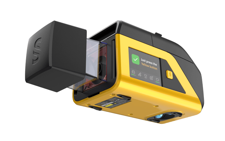
YellowScan 於 2026 年 2 月美國丹佛市 GeoWeek 展會正式推出 Venturer LiDAR 系統。該產品針對需要資料主權與高精度量測的嚴苛任務環境設計,核心優勢包括符合 NDAA 規範、全本地端資料處理、搭載高精度 IMU 與雙相機模組、支援 360° 自適應掃描,以及與多款專業無人機相容。系統透過自有 CloudStation 軟體完成所有資料處理,確保合規性與資安,同時配備 Yellow Touch 顯示螢幕提供即時監控,適用於政府、國防及需要資料完整掌控的商業應用場景。
法國無人機 LiDAR 廠商 YellowScan 於 GeoWeek 2026 展會發表 Venturer 系統,具備符合 NDAA 規範、全本地端資料處理與高精度定位等特色,瞄準政府與國防採購市場。
重點速覽
- YellowScan 發表 Venturer LiDAR 系統,符合美國 NDAA 規範,強化政府採購適用性
- 全本地端資料處理,搭載自有 CloudStation 軟體,消除外部服務依賴提升資安
- 搭載 Trimble Applanix APX-RTX IMU 與雙全域快門相機,達成業界頂級定位精度
- 支援 360° 自適應掃描與多款專業無人機相容,提供高度靈活的應用方案
- 配備 Yellow Touch 顯示螢幕即時監控系統狀態,簡化操作人員工作流程
文章重點
- YellowScan Venturer LiDAR 系統於 2026 年 2 月 16 至 18 日在美國科羅拉多州丹佛市 GeoWeek 2026 展覽正式亮相。
- Venturer 符合美國 NDAA 法規,所有資料透過自研軟體 CloudStation 在本地端處理,不依賴外部雲端服務。
- 系統搭載 Trimble Applanix APX-RTX IMU,提供高精度定位,並配備雙全域快門嵌入式相機實現全視野彩色化。
- Venturer 支援 360° 自適應角度掃描,可與多款專業無人機及相機模組相容,部署彈性高。
- 操作人員可透過 Yellow Touch 顯示螢幕即時掌握系統狀態與任務就緒情況,提升現場作業效率。
YellowScan Venturer 系統亮相 鎖定政府採購與高安全應用
法國無人機 LiDAR 領導廠商 YellowScan 於 2026 年 2 月 16 至 18 日在美國科羅拉多州丹佛市舉辦的 GeoWeek 2026 展覽上,正式發表全新 Venturer LiDAR 系統。這款產品專為需要資料主權硬體、完全本地端資料處理,以及限制操作存取的高風險任務環境所開發,標誌著 YellowScan 在政府與國防採購市場的進一步突破。
符合 NDAA 規範 消除政府採購障礙
Venturer 最核心的賣點在於符合美國《國防授權法案》(NDAA) 規範。在當今地緣政治局勢下,美國政府與盟友國家對採購無人機硬體的國家安全審查日益嚴格。Venturer 透過確保所有資料處理均在本地端、完全不依賴雲端或外部服務進行,直接解決聯邦採購與國防部門的合規需求。
系統搭載 YellowScan 自行開發的 CloudStation 軟體,負責所有資料處理工作。這個設計確保了資料主權——操作人員對所有蒐集的資訊擁有完整掌控權,無任何第三方中介,大幅降低資安風險並簡化合規驗證流程。
硬體層級的精度與可靠性
Venturer 搭載 Trimble Applanix APX-RTX IMU (慣性測量單元),這是測量與無人機領域的業界高端配置,提供卓越的定位精度與可靠性。配合雙全域快門嵌入式相機,系統可於單次飛行任務中蒐集完整的彩色化 LiDAR 點雲資料,無需多次往返或複雜的後製處理流程。
系統支援 360° 自適應角度掃描,這意味著無論在城市峽谷、森林密集區或複雜工業環境,Venturer 都能自動調整掃描參數確保完整資料擷取。同時系統相容多款市場主流專業無人機平台,包括固定翼與多旋翼配置,提供無與倫比的應用靈活性。
簡化操作與即時掌控
Venturer 配備 Yellow Touch 顯示螢幕,讓操作人員可在飛行現場即時監控系統狀態、電池續航、資料品質與任務就緒情況,無需仰賴複雜的地面站軟體或無線連接。這個設計特別適合進行偏遠地區或通訊受限的任務環境。
從投資報酬率角度,Venturer 透過降低系統整合負擔、提升作業可靠性與資料品質,幫助測量專業人員與國防單位在第一時間交付高精度成果,減少重飛與後製成本。
市場定位與戰略意義
Venturer 的推出標誌著無人機 LiDAR 市場的分化——消費與輕商用市場追求成本與易用性,而政府、國防及高安全性應用市場則優先考量資料主權、合規性與精度可驗證性。YellowScan 透過 Venturer 明確切割這一細分市場,預期將吸引美國聯邦機構、國防承包商、地理資訊廠商與高端測量公司的採購關注。
對台灣業者的意義
對台灣無人機測量與巡檢業者而言,YellowScan Venturer 的推出提示了兩大產業轉向:其一,政府與國防採購標案正逐漸納入 NDAA 合規條款,預期台灣民航局與國防部未來公開招標基礎測量與基建巡檢案件時,也會援用類似「資料本地端處理」、「符合國家安全規範」的要求。其二,Venturer 的高精度配置(Trimble IMU、雙相機)與多無人機相容設計,設定了業界新的技術標竿,台灣既有以輕量化 LiDAR 為主的廠商需評估是否補強精度與合規認證以保持競爭力。建議台灣業者關注政府採購政策走向,並評估引進或代理符合 NDAA 規範的系統以開拓公部門市場。
常見問題
Newsletter
訂閱低空產業電子報
每日精選低空經濟與無人機產業新聞,直送您的信箱。
本文由 LAETimes 編輯部審核發佈 ·