澳洲國防部隊測試無人機技術 強化海岸線測量精準度
澳洲國防團隊近期對海灘與淺水區域地形測量進行新興技術實地測試,重點整合無人機空拍測量、水下聲納掃描及多光譜影像分析等工具。此舉突破傳統測量方式在潮間帶、砂質海灘及淺水區域的限制,為兩棲登陸作戰、人道救援及災害應變等軍事行動提供更精準的地理空間資訊。測試成果將驗證這些技術在實戰環境中的可靠性,預計後續將公布完整報告。
澳洲國防團隊近期完成海灘與淺水環境地形測量的新興技術實地測試,整合無人機空拍、水下聲納及多光譜影像分析,為兩棲作戰及海岸防衛提供更精準的地理空間資訊支援。
重點速覽
- 國防團隊測試無人機空拍、聲納掃描、多光譜影像等技術組合應用於海岸測量
- 新技術突破潮間帶、砂質海灘等複雜地形的傳統測量限制
- 精確地形資料對兩棲登陸、人道救援、災害應變等軍事行動至關重要
- 測試驗證技術在實際作戰環境中的可靠性與實用性
- 完整測試報告將由相關國防單位後續公布
文章重點
- 一支國防團隊完成海灘與淺水環境新興測量技術的實地測試,驗證其在複雜地形中的可靠性。
- 此次測試涵蓋無人機空拍、水下聲納掃描及多光譜影像分析等多項現代化地理空間資訊蒐集技術。
- 海岸地形精確測量對兩棲登陸作戰、人道救援與災害應變任務規劃具有關鍵戰略價值。
- 新技術的導入預計大幅改善傳統測量方式在潮間帶與淺水區所面臨的操作限制。
澳洲國防部隊強化海岸測量能力
澳洲國防單位近期完成一項重大技術驗證計畫,針對海灘與淺水環境的地形測量任務進行多項新興科技的實地測試。此次測試標誌著軍事地理空間資訊蒐集能力的重要里程碑,為未來兩棲作戰及海岸線防衛工作奠定更堅實的技術基礎。
克服傳統測量瓶頸
海岸地形測量工作面臨多項挑戰。潮間帶、砂質海灘及淺水區域等複雜環境,往往超出傳統陸地測量設備的適用範圍,造成資料蒐集的死角。此次測試特別著眼於突破這些限制,整合多種補充性技術,形成立體化的測量方案。
多元技術整合應用
測試方案包含三大技術支柱:
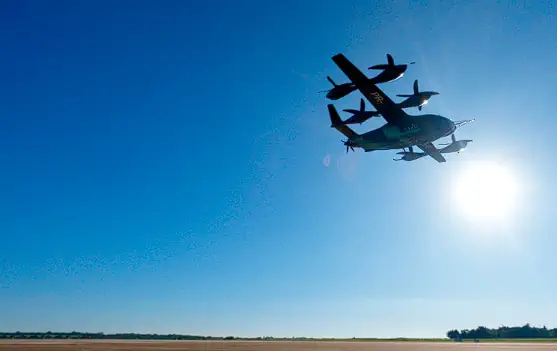
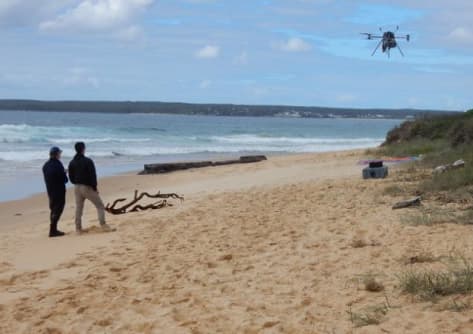
無人機空拍測量 — 利用無人機搭載高解析度相機與攝影測量系統,快速蒐集海灘及淺水區域的影像資料,並透過後處理軟體生成精密的三維地形模型。
水下聲納掃描 — 採用多波束聲納技術,對淺水區域進行高精度的海床地形掃描,補足光學影像在水下環境的不足。
多光譜影像分析 — 利用多光譜感測器捕捉不同波長的地物反射資訊,增強對海灘沙粒成分、淺灘邊界等特徵的識別能力。
軍事應用的關鍵價值
海灘與淺水環境的精確地形資料,對軍事行動規劃具有決定性影響。在兩棲登陸作戰中,精準的地形知識能幫助規劃兵力投放路線、灘頭據點及後勤補給路徑;在人道救援及災害應變場景中,詳細的地形圖資能加速搜索救援行動的效率。此次測試預期將進一步驗證這些整合技術在實際作戰環境中的可靠性與戰術實用性。
後續報告與技術推廣
相關國防單位表示,完整的測試報告及詳細技術細節將於後續時間公布。此舉預料將為澳洲及其盟國的地理空間情報(GEOINT)部隊提供新的能力參考基準。
對台灣業者的意義
對台灣無人機產業而言,此案例凸顯軍民整合測量技術的發展趨勢。本地從事基礎設施巡檢、測量測繪的業者,應關注無人機與聲納、多光譜等異質感測器的整合方案;同時,在國防部隊強化海岸防衛能力的背景下,台灣廠商若能發展適應複雜濱海環境的無人機系統(如防鹽霧、高精度定位等),將有機會進入軍方採購市場。此外,相關技術標準與操作規範的公開,有助於台灣海岸管理、防災等民間部門完善自身的地形測量能力。
常見問題
Newsletter
訂閱低空產業電子報
每日精選低空經濟與無人機產業新聞,直送您的信箱。
本文由 LAETimes 編輯部審核發佈 ·