零干擾高精度測量新時代:McKim & Creed 開發虛擬控制對齊技術,在營運中橋梁與機場跑道實現公分級精度
McKim & Creed 開發的虛擬控制對齊工作流程,透過靜態地面 LiDAR 與移動式 LiDAR 的混合方案,以結構本身的護欄、路緣石等剛性表面取代實體測量目標,在不中斷交通、不設置目標的條件下,於 Cape Fear 紀念橋實現公分級精度測量。團隊並透過可變脈衝重複率與內建震動通知系統,控制通車荷載下的結構振動影響。該技術進一步應用於商業機場跑道的夜間高解析度鋪面檢測,利用雙掃描儀系統達成兩毫米像素解析度,可供機場改建規劃使用。
美國測量公司 McKim & Creed 開發「虛擬控制對齊」工作流程,以結構本身幾何特徵取代實體測量目標,在不封閉車道、不中斷營運的條件下,於北卡羅來納州 Cape Fear 紀念橋實現公分級精度測量,並進一步應用於商業機場跑道夜間檢測。
重點速覽
- McKim & Creed 以虛擬控制對齊法結合靜態與移動式 LiDAR,達成不干擾營運的公分級測量
- Cape Fear 紀念橋專案無需封閉車道,即達成 NCDOT A 型精度要求,驗證通車條件下測量可行性
- 機場跑道夜間檢測採雙掃描儀系統達兩毫米像素解析度,可偵測裂縫與剝落
- 虛擬控制法透過殘差分析、水平截面比較與垂直面對面核查三層驗證
- 該方法論已納入 McKim & Creed 標準作業程序,可複製應用於高流量廊道與受限都市環境
文章重點
- McKim & Creed 開發「虛擬控制對齊」工作流程,以結構既有幾何平面取代實體測量目標,在 Cape Fear 紀念橋通車情況下達到 NCDOT A 型公分級精度要求,無需封閉任何車道。
- Cape Fear 紀念橋為 1969 年建造的四線道垂直升降橋,在持續通車振動環境下,團隊以 1,200 kHz 高脈衝重複率搭配 IMU 震動通知,將振動效應控制在可過濾雜訊範圍。
- 虛擬控制方法現已成為 McKim & Creed 標準作業程序,適用於高流量廊道、受限都市環境及任何無法安全設置實體控制點的基礎設施。
- McKim & Creed 正將技術擴展至商業機場跑道夜間鋪面檢測,以雙掃描儀行動測繪系統實現兩毫米像素解析度,主要資料採集於 2026 年 6 月啟動。
- 機場夜間跑道測量提供兩毫米解析度的裂縫、剝落與斷層資料,可讓設計團隊逐段區分修繕與換鋪決策,在維持機場正常營運下節省大量現場勘查人力。
零干擾精度新標準:虛擬控制對齊重塑基礎設施測量
基礎設施業主對測量工作的要求正在悄然轉變。不再只是「能否達到精度規格」,而是「能否在不中斷營運的情況下達到」。美國土木工程與測量公司 McKim & Creed 透過開發「虛擬控制對齊」工作流程,直接回應了這項挑戰。
Cape Fear 紀念橋的難題與突破
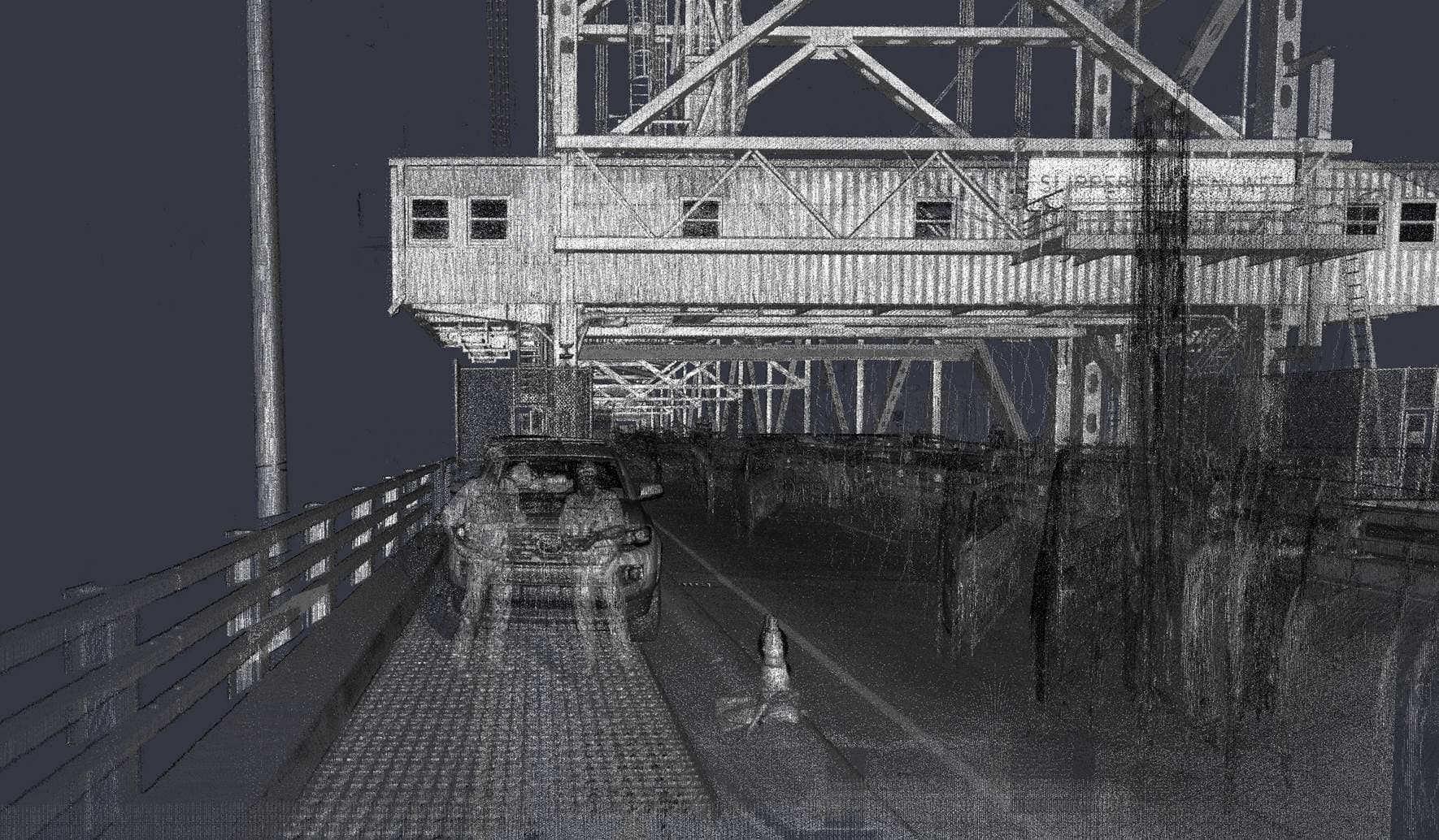
位於北卡羅來納州威明頓市的 Cape Fear 紀念橋建於 1969 年,是一座四線道垂直升降橋,跨越持續通航的河道。北卡羅來納州交通部(NCDOT)要求對整座結構——包含升降跨段、橋台、周邊建物與引橋——建立公分級精度的測量級 3D 模型,但有明確限制:不得封閉車道,不得干擾船隻通行或橋梁升降作業。
傳統以目標為基礎的移動式 LiDAR 作業,必須大規模封閉車道並進行夜間施作,才能安全設置測量目標——這在繁忙橋梁上根本不可行。McKim & Creed 全國業務發展暨地理空間服務總監 Matt LaLuzerne 指出,團隊在規劃階段就開始探討替代控制策略,最終開發出一套讓限制條件變得無關緊要的工作流程。
虛擬控制對齊工作流程
解決方案的核心是「虛擬控制對齊」——以結構本身既有的幾何資訊取代離散實體目標的方法論。
工作流程結合兩種互補的採集方式:
- 靜態掃描:高解析度地面 LiDAR 部署於引橋東端安全位置(停車區域、管橋員室附近),透過 GNSS 與傳統水準測量直接連結至 NCDOT 基準控制點
- 移動掃描:移動式 LiDAR 系統行駛全橋及引橋廊道,西岸以傳統方式連結至控制點
後製處理階段是創新關鍵。團隊以結構本身作為控制依據,選用混凝土護欄、路緣石、欄杆及橋面板等大面積、連續且結構剛性的表面,這些平面取代了實體目標,在最小二乘法平差中提供校準與調整移動資料集所需的幾何錨點。
「我們優先選用大面積、連續且結構上具有剛性的表面,」LaLuzerne 說,「目標是在最小二乘法平差中最大化幾何槓桿效益與冗餘度。」
振動控制與精度驗證
通車荷載引發的結構振動會造成點雲模糊。團隊透過可變脈衝重複率與內建震動通知系統的機載 IMU 應對這項挑戰。
在振動最明顯的管橋員室附近,以 1,200 kHz 重複率操作,將掃描位置停留時間降至最低,使振動效應停留在高頻雜訊範圍。在振動風險較低但距離較遠的引橋與落橋版位置,重複率調降至 140 kHz 至 600 kHz,確保足夠的飛行時間獲得遠距離精確回波。IMU 超過可接受閾值時自動發出警示。
最終成果達成 NCDOT A 型地面移動式 LiDAR 精度要求——無封閉車道、無夜間作業、無干擾船隻或橋梁升降、全結構公分級精度。
驗證工作透過三項平行核查進行:最小二乘法平差殘差分析、靜態與移動資料集的水平截面比較,以及重疊區域的垂直面對面差值計算。殘差分析顯示調整後殘差分布隨機均勻而非系統性;水平截面對比呈現緊密側向吻合;垂直核查確認兩個獨立控制資料集在引橋東段重疊區域的面對面差值維持公分級精度。
機場跑道:午夜的兩毫米革命
Cape Fear 成功後,McKim & Creed 將技術推向全新戰場——商業機場跑道的夜間高解析度鋪面檢測。
傳統跑道檢測需在白天關閉跑道,安排檢測人員步行或駕車勘查。McKim & Creed 的方案截然不同:在短暫排定的夜間時段進行採集,幾乎不影響機場營運與收益。
團隊使用雙掃描儀行動測繪系統,將 LiDAR 與向下拍攝相機配對,相機校準至點雲,達成兩毫米像素解析度——足以偵測鋪面裂縫、剝落與斷層。專用鋪面相機座架專為近垂直向下拍攝最佳化。
最大挑戰在於夜間照明與相機校準。團隊在不同高度和角度安裝燈條,調整相機增益設定,精確控制車速以最佳化夜間影像品質。作為準備工作,團隊在類似路面和條件下進行了多次測試。
測試與校準於 2026 年春季展開,主要資料採集於 6 月開始。據 LaLuzerne 所知,這種特定組合——在夜間從移動式 LiDAR 對通行中跑道採集高解析度正射影像——此前從未有人實現過。
兩毫米解析度足以為機場改建規劃提供直接應用價值,讓設計團隊在逐段基礎上區分修繕與換鋪決策,可能產生重大施工成本差異。「我們相信這將為機場改建產業帶來革命性的轉變,」LaLuzerne 說,「提供高解析度正射影像與地形資料供桌面審查,為設計團隊節省大量現場作業時間,同時維持機場正常運作與收益。」
可複製的標準流程
Cape Fear 案例已成為 McKim & Creed 的標準作業程序,納入內部作業清單與處理指引。只要靜態掃描中可見、且在具有良好控制的移動掃描中同樣可見的結構,任何團隊都能加以實施。
該公司視此技術可複製應用於高流量廊道、受限的都市環境,以及任何設置實體控制點不切實際或不安全的基礎設施場域。其驅動力來自三個核心需求:安全要求、速度與精度。
對台灣業者的意義
虛擬控制對齊技術對台灣測量與基礎設施巡檢業者具有直接應用價值。台灣橋梁、高架道路與機場跑道的檢測與維護,多因营運中斷限制而採用高成本夜間施作或部分封閉。此技術可讓業者在不中斷交通的條件下取得公分級精度資料,大幅降低營運成本與安全風險。對採用 LiDAR 的測繪服務商與工程顧問而言,掌握虛擬控制對齊的工作流程將成為競爭優勢。同時,相應的硬體配置(靜態與移動式 LiDAR、IMU 震動監測、點雲處理軟體)亦可成為代理商與系統整合商的新商機。台灣民航局與交通部應關注此技術對機場與橋梁養護規範的影響,預期後續將有檢測標準的更新。
常見問題
Newsletter
訂閱低空產業電子報
每日精選低空經濟與無人機產業新聞,直送您的信箱。
本文由 LAETimes 編輯部審核發佈 ·