來源:GeoConnexion
原文連結 Leica Geosystems 推出全新 RTC 系列地面雷射掃描儀,樹立掃描精度與生產力新標竿
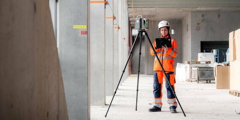
Hexagon 旗下 Leica Geosystems 發表全新 Leica RTC 系列地面雷射掃描儀,包括 RTC300、RTC500 及 RTC700 三款機型,旨在為測量測繪產業設立掃描精度與作業效率的全新基準。
LAETimes 編輯部AI 輔助編譯・經編輯部審核 ·
大約 2 個月前
文章重點
- Leica Geosystems 發表全新 RTC 系列,涵蓋 RTC300、RTC500、RTC700 三款地面雷射掃描儀
- Leica Geosystems 為 Hexagon 旗下品牌,深耕測量測繪與地理空間技術
- RTC 系列定位為掃描精度與生產力的全新業界標竿
- 適用於測量測繪、基礎設施巡檢及建築工程等多元應用場景
Leica Geosystems 發表全新 RTC 系列地面雷射掃描儀
Hexagon 旗下的 Leica Geosystems 正式宣布推出全新 Leica RTC 系列地面雷射掃描儀,涵蓋 Leica RTC300、RTC500 及 RTC700 三款機型。
此次發表的 RTC 系列定位為掃描精度與生產力的全新標竿,針對測量測繪、基礎設施巡檢及建築工程等應用場景,提供更高效率的三維空間資料擷取方案。
三款機型一次到位
- Leica RTC300
- Leica RTC500
- Leica RTC700
三款機型共同組成完整的產品線,滿足不同規模與精度需求的專業使用者。Leica Geosystems 長期以來在地面雷射掃描領域擁有領先地位,此次全新系列的推出,預計將進一步鞏固其市場優勢。
隨著無人機搭載 LiDAR 等空載掃描技術日益普及,地面雷射掃描儀與無人機測繪的整合應用也持續深化,為測量專業人員提供更完整的空間資料解決方案。
原文來源: 查看原文
常見問題
Newsletter
訂閱低空產業電子報
每日精選低空經濟與無人機產業新聞,直送您的信箱。
本文由 LAETimes 編輯部審核發佈 ·