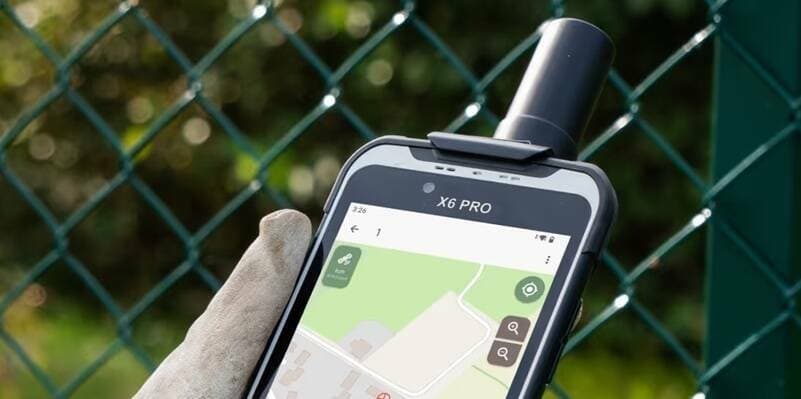
Soarvo Mobile 整合 Nordalp X6 Pro RTK,為測繪專業人員提供高精度野外採集方案
Nordalp 與 Soarvo Mobile 完成硬體整合,將 X6 Pro RTK 加固型 PDA 納入 Soarvo Mobile 的相容設備清單。X6 Pro 搭載 RTK 即時動態定位技術,可在野外環境提供公分級精度的位置資訊,特別適用於測量測繪、基礎設施巡檢及地圖製作。此整合為地理空間專業人員建立軟硬體一體化工作流程,強化外業數據採集的效率與精確度。
Nordalp 宣布將 X6 Pro RTK 加固型 PDA 整合至 Soarvo Mobile 測繪應用,讓地理空間專業人員能在惡劣環境中進行公分級精度的空間數據採集作業。
重點速覽
- Nordalp X6 Pro RTK 正式支援 Soarvo Mobile,擴展測繪應用硬體相容性
- RTK 技術提供公分級定位精度,適合測量、巡檢、製圖等專業應用
- 加固型 PDA 設計能在惡劣環境下穩定運作,提升外業數據品質
- 整合方案簡化軟硬體配置,提高測繪工作流程效率
- 面向測量、GIS、環境監測等領域的專業人員提供一體化解決方案
文章重點
- Nordalp 宣布將 X6 Pro RTK 加固型 PDA 整合至 Soarvo Mobile 測繪應用程式。
- Nordalp X6 Pro RTK 採用加固型設計,支援 RTK 即時動態定位,可提供公分級定位精度。
- 此次整合專為地理空間專業人員打造,適用於野外高精度數據採集作業。
- Soarvo Mobile 透過支援 X6 Pro RTK,進一步擴展其相容硬體生態系,提升外業作業靈活性。
硬體整合擴大測繪應用生態
Nordalp 近期完成了 X6 Pro RTK 加固型個人數位助理(PDA)與 Soarvo Mobile 測繪應用程式的整合,為地理空間領域的專業工作者帶來更完善的野外數據採集方案。這項整合展現了當代測繪工具朝向軟硬體緊密配合的發展方向。
X6 Pro RTK 的核心優勢
Nordalp X6 Pro 採用加固型工業級設計,搭載 RTK(即時動態定位)技術,可在開闊的野外環境中提供公分級(通常在 2-5 公分範圍內)的絕對位置精度。相較於標準 GPS 定位,RTK 透過即時基地台修正信號,大幅縮小定位誤差,使其成為高精度測量作業的關鍵工具。
該設備在硬體層面具備防塵防水(通常達 IP67 等級)與防摔設計,能在工地、山區、沿海等環境較為惡劣的場景中持續運作,減少設備損失風險,降低外業成本。
Soarvo Mobile 應用生態擴展
Soarvo Mobile 作為專業級行動測繪應用,原本已支援多種 RTK 接收器與行動設備,此次納入 X6 Pro 則進一步豐富其硬體相容性。使用者能在 Soarvo Mobile 的統一界面下,靈活選配不同廠牌的 RTK 設備,避免被單一硬體廠商綁定,提升系統靈活性。
應用場景與市場意義
此整合方案特別適用於以下領域:
- 測量測繪:建築、土木工程前置調查與放樣作業
- 基礎設施巡檢:電力、通訊、水利等設施的空間資訊更新與管理
- 地圖製製作:地政、環保、城市規劃部門的圖資採集與建檔
- 環境監測:自然資源調查、災害評估的地理資訊蒐集
對於需要在複雜現場環境中快速取得高精度座標的專業人員,X6 Pro 與 Soarvo Mobile 的結合提供了既耐用又精確的一體化工作流程,有助於加快外業進度、降低重測率、提升數據品質。
對台灣業者的意義
在台灣,測繪、地政、水利、環保等公務單位及民間測量技師均面臨高精度外業數據採集的需求。Nordalp X6 Pro RTK 與 Soarvo Mobile 的整合,為本地測繪業者提供了新的硬體選項。特別是經濟部國土測繪中心、各縣市地政單位及民間測量公司,可透過此組合改善野外採集流程。目前台灣市場對 RTK 測繪設備的需求穩定成長,此整合有助於 Soarvo Mobile 在本地的市場滲透,也鼓勵國內測繪軟體與硬體廠商加強相容性設計,推動台灣測繪技術服務的現代化升級。
常見問題
Newsletter
訂閱低空產業電子報
每日精選低空經濟與無人機產業新聞,直送您的信箱。
本文由 LAETimes 編輯部審核發佈 ·