Tessera推出地球觀測AI基礎模型 整合衛星多源數據破解遙測分析瓶頸
地球觀測公司Tessera推出新一代AI基礎模型,整合歐洲太空總署Sentinel衛星的光學影像與合成孔徑雷達數據,生成高精度嵌入向量供機器學習使用。該技術透過預訓練模型可快速適配農業監測、城市規劃、災害評估等多元應用場景,降低開發成本,標誌著遙測技術與生成式AI深度融合的新里程碑。
新興AI公司Tessera發布專用基礎模型,融合ESA Sentinel衛星的光學與雷達數據生成高精度嵌入向量,為地球觀測和地理空間分析領域注入新動能。
重點速覽
- Tessera推出地球觀測專用AI基礎模型,整合Sentinel光學與SAR雷達雙源數據
- 嵌入向量技術將影像轉換為高維數值,提升農業監測、災情評估等應用效率
- 基礎模型可針對下游任務微調,大幅降低企業與政府單位的訓練成本與時程
- Sentinel衛星數據免費開放,結合AI基礎模型降低全球遙測應用門檻
- 模型融合多源數據克服天候限制,即使雲層遮蔽仍能進行全天候地表監測
文章重點
- Tessera推出專為地球觀測設計的AI基礎模型,同時整合Sentinel-1雷達與Sentinel-2光學衛星數據。
- 該模型將衛星影像轉換為高精度嵌入向量(embeddings),供下游地理空間分析任務使用。
- 基礎模型架構允許使用者針對特定應用場景進行微調,大幅降低訓練成本與開發時間。
- Sentinel衛星數據由歐盟哥白尼計畫免費開放,雷達影像可穿透雲層實現全天候監測。
AI與衛星遙測的深度融合
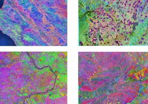
地球觀測領域迎來新轉機。新興AI公司Tessera日前推出專為遙測設計的基礎模型,藉由整合歐洲太空總署(ESA)Sentinel衛星系列所提供的光學影像與合成孔徑雷達(SAR)數據,生成高度精細的訓練資料「嵌入向量」,為地球觀測與地理空間分析領域帶來技術突破。
嵌入向量:連接數據與AI的橋樑
嵌入向量(embeddings)是現代機器學習的核心技術,將原始影像、文字等非結構化數據轉換為計算機能夠理解的高維度數值向量。在地球觀測應用中,嵌入向量使AI模型能更有效率地學習並辨識地表特徵變化——從農田生長週期、城市擴張軌跡,到洪水災情分佈與植被覆蓋動態,都可通過向量化表示進行快速分析。
Tessera的創新之處在於,該模型同時吸收Sentinel衛星的多源異質數據,而非單一數據流。這種多源融合設計使其在複雜氣候條件下仍能維持高準確率。
Sentinel數據:全球免費的遙測資產
Sentinel衛星系列是歐盟哥白尼計畫(Copernicus Programme)的核心資產,向全球提供免費開放的地球觀測數據。其中:
- Sentinel-2光學影像:高解析度多光譜影像,適用於土地利用分類、農業監測、環境評估等應用
- Sentinel-1雷達數據:合成孔徑雷達可穿透雲層與雨霧,實現全天候地表監測,對災害應對至關重要
兩者搭配使用,彌補各自的短板——光學影像解析度高但受天候影響,雷達無天候限制但空間細節較粗。Tessera的基礎模型正是透過同時整合雙源數據,克服單一傳感器的先天限制。
基礎模型的產業解放
基礎模型的概念源自大型語言模型(GPT系列)的成功,其核心價值在於一次訓練、多次應用。完成預訓練後,可針對不同下游任務進行輕量微調(fine-tuning),大幅降低個別應用場景所需的計算資源與開發時程。
對於地球觀測產業而言,這意味著:
政府機構、學術單位與企業可更快速部署遙測分析應用,無需從零開始訓練模型
中小型團隊因為預訓練成本被分攤,進入遙測應用領域的門檻大幅降低
跨域應用協作通過統一的嵌入向量表示,不同場景的數據可直接比較與共用
市場與機會
隨著衛星發射成本下降與數據衛星數量增加,全球遙測數據量呈爆炸性成長。如何從海量影像中高效提取有價值的資訊,已成為地理空間產業的核心挑戰。Tessera此舉正面回應這一痛點——通過AI基礎模型將複雜的影像分析任務標準化、模塊化,加速遙測技術在農業、城市規劃、環境監測、災害應對等領域的實際應用落地。
對台灣業者的意義
對台灣業者的影響主要集中在三個層面:首先,農業植保與精準農業服務商可透過Tessera基礎模型快速開發作物監測應用,降低自建AI模型的成本障礙;其次,基礎設施巡檢業者(如電力、水利、交通)可利用多源衛星數據進行大尺度資產監測,拓展服務範圍;第三,台灣若無人機遙測與地理空間新創可與Tessera或類似平台合作,整合無人機近距離影像與衛星遠程數據,形成多尺度融合分析能力。惟需注意,免費開放的Sentinel數據雖降低成本,但台灣業者仍應評估是否引進或開發本地化模型,以應對特定產業需求與資料隱私考量。
常見問題
Newsletter
訂閱低空產業電子報
每日精選低空經濟與無人機產業新聞,直送您的信箱。
本文由 LAETimes 編輯部審核發佈 ·