無人機磁力測量重啟內華達州70年塵封鎢礦,Western Star 以低成本勘探重塑礦業經濟學
加拿大上市礦業公司 Western Star Resources 以無人機搭載磁力儀技術,對內華達州 Charleston 採礦區的 White Star 鎢礦進行高解析度勘探。這是該地點近75年來首次現代化測量。無人機磁力測量相比傳統直升機測量,成本大幅降低,使初級礦企得以用有限預算產出精細構造地圖並定位鑽探目標。該公司已在 Rowland 項目驗證此模式,結果識別出多條可能導引熱液流體的斷層特徵。無人機技術正悄然改寫礦產勘探經濟學,使美國本土鎢礦供應重新具備商業可行性。
加拿大上市礦企 Western Star Resources 以搭載磁力儀的無人機勘探內華達州 White Star 鎢礦,這是該地自1950年代以來首次現代化探測。無人機磁力測量正以遠低於直升機的成本,讓初級礦業公司也能產出精細構造地圖,逐漸重寫礦產勘探的經濟邏輯。
重點速覽
- Western Star 於6月22日宣布在內華達州 Elko 郡進行無人機磁力測量,尋找矽卡岩型鎢鉬礦化帶
- 該礦區自1950年代起即無人開採,無人機磁力資料可揭示肉眼無法發現的地下構造特徵
- 無人機磁力測量成本僅為直升機測量的一小部分,兩人團隊加皮卡車即可部署完成
- Rowland 項目已驗證此作業模式,兩項目合計覆蓋逾6公里矽卡岩潛力層位
- 鎢在美國關鍵礦物供應鏈上具戰略重要性,中國控制全球超80%產量並設置出口管制
文章重點
- Western Star Resources 於6月22日啟動 White Star 鎢礦項目高解析度無人機磁力測量,該礦區自1950年代後首次接受現代化勘探。
- 公司以7萬美元現金加300萬股股份取得 White Star 礦區,並附1%淨冶煉廠回報權利金。
- 同在 Elko 郡的 Rowland 鎢礦項目已完成無人機磁力測量,結果顯示多條北東至西南走向斷層或裂縫構造特徵。
- 兩個項目合計覆蓋逾6公里矽卡岩潛力層位,歷史性 Mission Cross 礦山曾產出品位高達1%氧化鎢的礦石。
- 中國掌控全球逾80%鎢供應,美國積極推動關鍵礦物供應鏈自主,無人機磁力測量正讓低成本找礦成為可能。
無人機喚醒塵封70年的內華達州鎢礦
一家初級礦業公司正以無人機磁力測量技術重新繪製一處自1950年代便無人開採的內華達州鎢礦。加拿大證券交易所上市公司 Western Star Resources(代碼:WSR)於6月22日宣布,對位於內華達州 Elko 郡 Charleston 採礦區的 White Star 鎢礦項目進行高解析度無人機磁力測量作業,同步配合土壤與岩石碎片採樣,目標是精確定位矽卡岩型鎢鉬礦化帶,建立鑽探目標。
此次勘探作業預計數週內將收到承包商的分析結果,這也標誌著該礦區近75年來首次動用現代勘探技術。
磁力儀揭示肉眼無法發現的地下構造
無人機搭載的磁力儀透過偵測岩石中的磁性對比差異,識別斷層、裂縫及蝕變帶等地質特徵。這些構造特徵往往與熱液流體曾經活動的路徑相吻合,也是控制鎢礦矽卡岩礦床形成的關鍵地質因素。
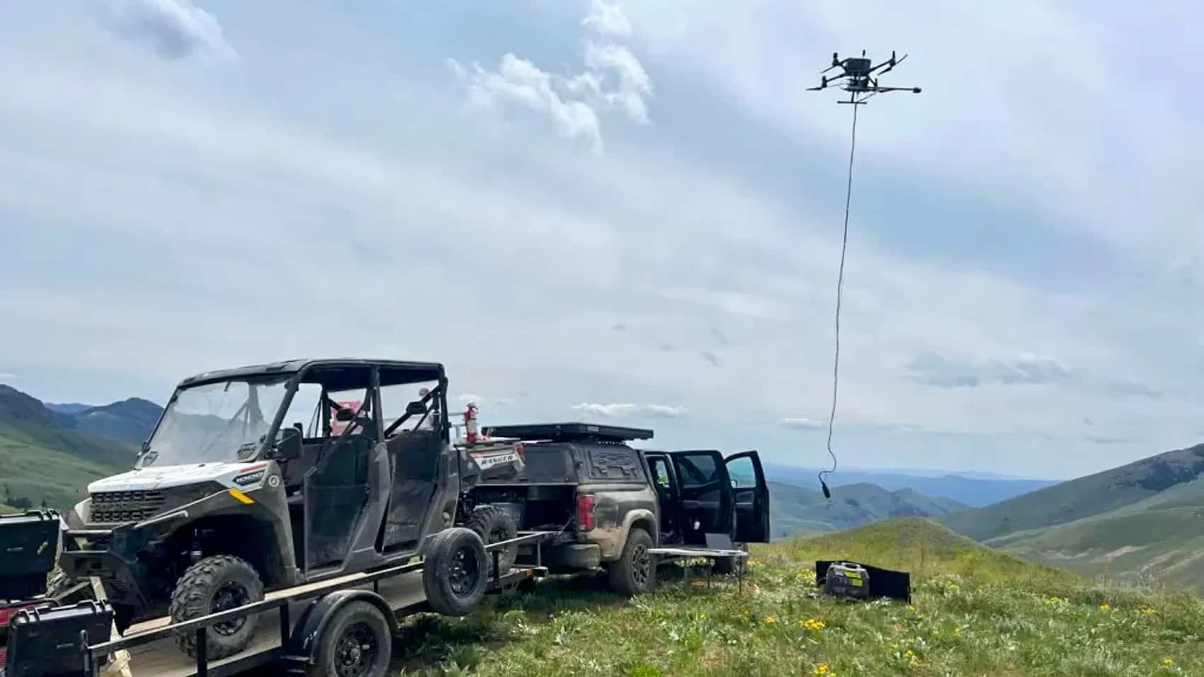
美國西部大多數具生產潛力的鎢礦區,上次有系統開採紀錄都停留在1950年代。當時的地質作業完全依靠人工繪圖,礦化帶若非肉眼可見,便極可能被忽略。無人機磁力資料集能夠揭示原始探礦者根本無從發現的勘探目標,且無需任何人員背著重型儀器在山區艱苦跋涉。
低成本破局初級礦企的資金困境
Western Star 執行長 Blake Morgan 直言不諱地表示:「在 White Star 採礦區執行整合式無人機磁力測量,並配合聚焦性土壤與岩石碎片採樣,是定義鑽探目標的最快途徑。」在初級採礦業中,「最快」往往也意味著「最省錢」。
該公司在5月以7萬美元現金加300萬股股份取得 White Star 礦區經營權,另付1%淨冶煉廠回報權利金給原業主。對於手握有限現金的初級礦企而言,成本控制至關重要。
過去,直升機載磁力測量是覆蓋內華達州規模礦區的唯一可行方式,但成本高昂且動員緩慢。無人機磁力測量徹底改變了這道經濟算術:無人機飛行高度更低、對近地表構造的解析度更高、成本僅為直升機日費的一小部分,且兩人團隊加一輛皮卡車即可完成部署。
這使得過去現金不足以支撐直升機勘探的小型公司,現在也能產出足以定位鑽機位置的精細構造地圖。原理與磁力儀技術相同,只是改由更小的飛行平台在數百英尺高空運作。
Rowland 項目驗證可複製的作業模式
White Star 並非 Western Star 首次採用此流程。6月17日,該公司發布同在 Elko 郡的 Rowland 鎢礦項目早期無人機磁力測量結果。經過全磁場強度(TMI)、一階及二階垂直導數與解析訊號等資料處理後,從雜訊中提取出多條北東至西南走向的線性構造特徵。
這些特徵被解釋為斷層或裂縫,可能曾引導熱液流體生成該區的鎢矽卡岩礦化帶。Rowland 的成果為 Western Star 提供了在 White Star 複製的作業範本。兩個項目合計覆蓋逾6公里的矽卡岩潛力層位。該系統內的歷史性 Mission Cross 礦山曾產出1,000噸品位高達1%氧化鎢的礦石,若能在規模上進一步確認礦床,此類品位在當今市場依然極具吸引力。
鎢礦勘探牽涉更廣泛的戰略意義
無人機磁力測量重新開啟沉睡數十年礦區的背景,涉及美國的關鍵礦物供應鏈戰略。鎢出現在美國政府的所有關鍵礦物清單上,用途涵蓋國防、航太、電子及工業應用。
中國生產全球超過80%的鎢,並已將出口管制應用在相關材料上作為地緣政治工具。任何可行的美國本土供應來源都具有戰略意義,但前提是找礦與驗證礦床的成本低到足以吸引真正的資本投入。無人機磁力測量正讓這件事逐漸成為經濟上可行的現實。
無人機並非只在軍事或警務領域改寫遊戲規則。在礦產勘探中,它同樣以不引人矚目的方式悄然改寫經濟邏輯:使原本因成本過高而被放棄的礦區重新具備開發價值。
對台灣業者的意義
對台灣無人機服務業者而言,Western Star 案例啟示了一個尚未充分開發的商業應用場景。台灣雖無大規模鎢礦資源,但具有豐富的地質構造、地下水位監測需求及環境調查需求,都可應用無人機磁力、重力或熱紅外感測。本案例尤其值得台灣礦業、地質調查及環境顧問公司參考,可探索引進類似的低成本無人機磁力測量服務。對於已具航空測量經驗的業者,此領域提供了從平面測量向深層地質應用的升級路徑,同時面向政府地質調查機構及大型基礎設施業主開拓新的商業機會。
常見問題
Newsletter
訂閱低空產業電子報
每日精選低空經濟與無人機產業新聞,直送您的信箱。
本文由 LAETimes 編輯部審核發佈 ·