Real-Time Airspace Situational Awareness: Building a Complete Air Intelligence Picture for Public Safety Agencies (BOS)
As drones become increasingly integral to emergency response and law enforcement, low-altitude airspace management grows more complex. Germany's Rhineland-Palatinate Police has integrated real-time airspace data into its command center, enabling unified monitoring of both manned and unmanned aircraft. Droniq's live airspace situational awareness interface embeds directly into existing command software, helping safety agencies detect airspace conflicts early and coordinate flight operations efficiently.

Highlights
- Droniq provides a real-time airspace situational awareness data interface that embeds directly into existing BOS command center software, eliminating the need for separate applications.
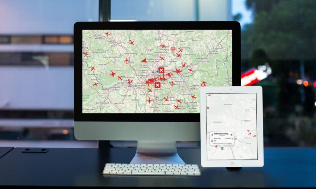
- The system displays live positions, altitude, speed, and heading of all manned and unmanned aircraft within a mission area on a single, unified air intelligence picture.
- Rhineland-Palatinate Police (Polizei Rheinland-Pfalz) has already integrated Droniq's live air traffic data into its command center for operational airspace monitoring.
- Integrated airspace situational awareness enables early detection of airspace conflicts and faster coordination of drone and aviation missions, particularly in large-scale events and multi-agency deployments.
- Fragmented air traffic data across standalone systems is identified as the primary risk factor for airspace conflicts during dynamic or parallel multi-unit emergency operations.
Operational Scenes Demand a Clearer Picture of the Airspace
As drones are deployed more widely across public safety applications, airspace conditions at operational scenes are becoming increasingly complex. Beyond the aircraft operated by the agencies themselves, a typical scene may simultaneously involve rescue helicopters, police aircraft, and civilian drones.
For authorities and organizations with security responsibilities — known in German as Behörden und Organisationen mit Sicherheitsaufgaben, or BOS — the ability to monitor and safely coordinate low-altitude airspace in real time has become an indispensable core capability.
The Challenge: Highly Fragmented Airspace Information
In many emergency scenarios, air traffic data is scattered across multiple standalone systems with no unified integration layer. Each system presents only a partial view of the airspace, making it difficult to build a complete operational picture.
This not only increases the complexity of coordination but, during dynamic missions or multi-agency deployments, significantly raises the risk of airspace conflicts.
Why Real-Time Airspace Situational Awareness Matters
An integrated real-time airspace situational awareness system creates a unified, continuously updated air intelligence picture, displaying:
- Live positions of both manned and unmanned aircraft
- Altitude, speed, and heading of every aircraft
- All relevant aerial activity within the mission area
This gives mission commanders the complete information they need to make fast, well-informed decisions.
System Integration, Not Another Silo
The true value lies in integrating directly into existing systems. Live air traffic data is delivered as a data stream that can be seamlessly embedded into existing command center software and decision-support platforms, offering:
- No need to open a separate application
- Consistent airspace information within a familiar user interface
- Rapid situational awareness at the operational scene
Enhanced Safety and Coordination Efficiency
With integrated airspace situational awareness, mission control centers can:
- Identify airspace conflicts at an early stage
- Coordinate drone and aviation missions more effectively
- Accelerate decision-making
This is particularly impactful during large-scale event security operations or multi-agency parallel deployments, where the system delivers significant improvements in both overall safety and mission efficiency.
Case Study: Rhineland-Palatinate Police
The Rhineland-Palatinate Police (Polizei Rheinland-Pfalz) serves as a concrete example of real-time airspace situational awareness in action. The force has integrated live air traffic data directly into its command center, maintaining a complete and current picture of the airspace across its operational areas and using it to strengthen coordination across all mission types.
Further details are available in the official press release and customer case study.
Real-Time Airspace Situational Awareness Is Becoming Essential for BOS
The demands placed on public safety agencies in airspace management continue to rise — and with them, the need to make well-considered decisions based on live data. Integrated real-time airspace situational awareness is the critical foundation for achieving this: it provides a complete, up-to-the-minute, and immediately actionable air intelligence picture.
Learn more about the live airspace data interface
This article was originally published by Droniq
原文來源: 查看原文
FAQ
Newsletter
Subscribe to our Low-Altitude Industry Newsletter
Daily curated news on low-altitude economy and drone industry, delivered to your inbox.
Reviewed and published by the LAETimes editorial desk ·